Huai Yot geodata
Huai Yot (Trang) is a seat of a second-order administrative division; located in Thailand in Asia/Bangkok (GMT+7) time zone. With population of 16,586 people, there are 197 cities with bigger population in this country. Compared to other cities in Thailand, 91.3% of cities are located further ↑North; 82.2% of cities are located further →East and 56.4% of cities have higher elevation than Huai Yot. Note1


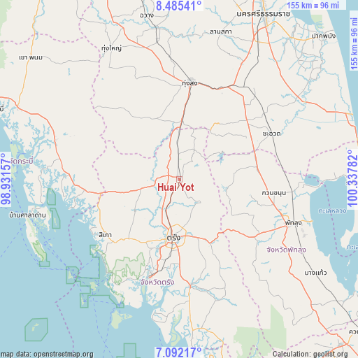
Huai Yot GPS coordinates[2]
7° 47' 21.732" North, 99° 38' 4.884" East
| Map corner | latitude | longitude |
|---|---|---|
| Upper-left | 8.48541°, | 98.93157° |
| Center: | 7.78937°, | 99.63469° |
| Lower-right: | 7.09217°, | 100.33782° |
| Map W x H: | 154.9×154.9 km | = 96.3×96.3mi |
| max Lat: | 20.43353° ⇑91.3% North |
| Huai Yot: | 7.78937° |
| min Lat: | ⇓8.7% South 5.77434° |
| min Long | Huai Yot | max Long |
| 97.93288° | 99.63469° | 105.49506° |
| W 17.8%⇐ | ⇒82.2% E |
Elevation
Elevation of Huai Yot is 54 m = 177 ft, and this is 71.5 m = 235 ft below average elevation for this country.
| Max E: |
1011 m = 3317 ft | 56.4% |
| Avg. | 125.5 m = 412 ft | |
| Huai Yot | 54 m = 177 ft | |
Min E: |
1 m = 3 ft | 43.6% |
See also: Thailand elevation on elevation.city.
Geographical zone
Huai Yot is located in North Torrid zone (between Equator and Tropic of Cancer). Distance of Equator is 866.1 km =538.2 mi to South.| Distance of | km | miles | from Huai Yot |
|---|---|---|---|
| North Pole | 9141 | 5680 | to North |
| Arctic Circle | 6535.1 | 4060.7 | to North |
| Tropic Cancer | 1739.8 | 1081.1 | to North |
| Equator | 866.1 | 538.2 | to South |


Nearby cities:
15 places around Huai Yot: (largest is in red/bold)
• Bang Khan
31.8 km =19.8 mi,  326°
326°
• Cha-uat
44.8 km =27.8 mi,  63°
63°
• Chulabhorn
41 km =25.5 mi,  39°
39°
• Kantang
44.7 km =27.8 mi,  197°
197°
• Khuan Khanun
41.7 km =25.9 mi,  98°
98°
• Na Yong
26.2 km =16.3 mi,  165°
165°
• Pa Phayom
31.7 km =19.7 mi,  79°
79°
• Ratsada
20.6 km =12.8 mi,  359°
359°
• Si Banphot
28.5 km =17.7 mi,  105°
105°
• Sikao
40.1 km =24.9 mi,  232°
232°
• Srinagarindra
41.9 km =26 mi,  125°
125°
• Thung Song
42 km =26.1 mi,  6°
6°
• Trang
26 km =16.2 mi,  185°
185°
• Wang Wiset
26.7 km =16.6 mi,  257°
257°
• Yan Ta Khao
45 km =28 mi,  175°
175°
Sources, notices
• [Note1] Compared only with cities in Thailand existing in our database
• [Src1] Map data: © OpenStreetMap contributors (CC-BY-SA)
• [Src2] Other city data from geonames.org with taken over terms of usage.
• [Src3] Geographical zone / Annual Mean Temperature by Robert A. Rohde @ Wikipedia
