Kantang geodata
Kantang (Trang) is a seat of a second-order administrative division; located in Thailand in Asia/Bangkok (GMT+7) time zone. With population of 14,156 people, there are 232 cities with bigger population in this country. Compared to other cities in Thailand, 93.2% of cities are located further ↑North; 84.9% of cities are located further →East and 83.5% of cities have higher elevation than Kantang. Note1


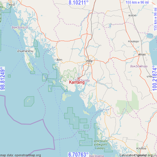
Kantang GPS coordinates[2]
7° 24' 19.512" North, 99° 30' 56.196" East
| Map corner | latitude | longitude |
|---|---|---|
| Upper-left | 8.10211°, | 98.81249° |
| Center: | 7.40542°, | 99.51561° |
| Lower-right: | 6.70763°, | 100.21874° |
| Map W x H: | 155.1×155.1 km | = 96.4×96.4mi |
| max Lat: | 20.43353° ⇑93.2% North |
| Kantang: | 7.40542° |
| min Lat: | ⇓6.8% South 5.77434° |
| min Long | Kantang | max Long |
| 97.93288° | 99.51561° | 105.49506° |
| W 15.1%⇐ | ⇒84.9% E |
Elevation
Elevation of Kantang is 11 m = 36 ft, and this is 114.5 m = 376 ft below average elevation for this country.
| Max E: |
1011 m = 3317 ft | 83.5% |
| Avg. | 125.5 m = 412 ft | |
| Kantang | 11 m = 36 ft | |
Min E: |
1 m = 3 ft | 16.5% |
See also: Thailand elevation on elevation.city.
Geographical zone
Kantang is located in North Torrid zone (between Equator and Tropic of Cancer). Distance of Equator is 823.4 km =511.6 mi to South.| Distance of | km | miles | from Kantang |
|---|---|---|---|
| North Pole | 9183.7 | 5706.5 | to North |
| Arctic Circle | 6577.8 | 4087.3 | to North |
| Tropic Cancer | 1782.5 | 1107.6 | to North |
| Equator | 823.4 | 511.6 | to South |


Nearby cities:
15 places around Kantang: (largest is in red/bold)
• Hat Samran
19.5 km =12.1 mi,  159°
159°
• Huai Yot
44.7 km =27.8 mi,  17°
17°
• Ko Lanta
49.4 km =30.7 mi,  286°
286°
• Kong Ra
47.9 km =29.8 mi,  90°
90°
• Manang
63.6 km =39.5 mi,  135°
135°
• Na Yong
26.3 km =16.3 mi,  48°
48°
• Palian
32 km =19.9 mi, 144°
• Saladan
57.7 km =35.9 mi, 293°
• Si Banphot
53.7 km =33.4 mi, 49°
• Sikao
26.4 km =16.4 mi,  314°
314°
• Srinagarindra
50.6 km =31.4 mi,  68°
68°
• Thung Wa
42.2 km =26.2 mi, 141°
• Trang
19.8 km =12.3 mi,  32°
32°
• Wang Wiset
39 km =24.2 mi,  340°
340°
• Yan Ta Khao
16.8 km =10.4 mi,  97°
97°
Sources, notices
• [Note1] Compared only with cities in Thailand existing in our database
• [Src1] Map data: © OpenStreetMap contributors (CC-BY-SA)
• [Src2] Other city data from geonames.org with taken over terms of usage.
• [Src3] Geographical zone / Annual Mean Temperature by Robert A. Rohde @ Wikipedia
