Si Banphot geodata
Si Banphot (Phatthalung) is a seat of a second-order administrative division; located in Thailand in Asia/Bangkok (GMT+7) time zone. In our database, there are 331 cities with bigger population. Compared to other cities in Thailand, 92% of cities are located further ↑North; 76.4% of cities are located further →East and 56.4% of cities have higher elevation than Si Banphot. Note1


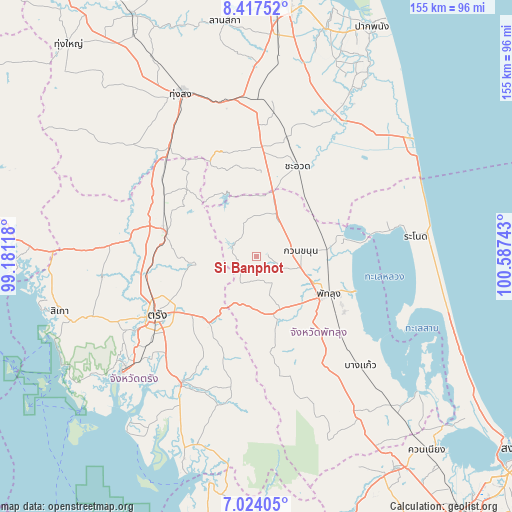
Si Banphot GPS coordinates[2]
7° 43' 16.896" North, 99° 53' 3.48" East
| Map corner | latitude | longitude |
|---|---|---|
| Upper-left | 8.41752°, | 99.18118° |
| Center: | 7.72136°, | 99.8843° |
| Lower-right: | 7.02405°, | 100.58743° |
| Map W x H: | 154.9×154.9 km | = 96.3×96.3mi |
| max Lat: | 20.43353° ⇑92% North |
| Si Banphot: | 7.72136° |
| min Lat: | ⇓8% South 5.77434° |
| min Long | Si Banphot | max Long |
| 97.93288° | 99.8843° | 105.49506° |
| W 23.6%⇐ | ⇒76.4% E |
Elevation
Elevation of Si Banphot is 54 m = 177 ft, and this is 71.5 m = 235 ft below average elevation for this country.
| Max E: |
1011 m = 3317 ft | 56.4% |
| Avg. | 125.5 m = 412 ft | |
| Si Banphot | 54 m = 177 ft | |
Min E: |
1 m = 3 ft | 43.6% |
See also: Thailand elevation on elevation.city.
Geographical zone
Si Banphot is located in North Torrid zone (between Equator and Tropic of Cancer). Distance of Equator is 858.5 km =533.4 mi to South.| Distance of | km | miles | from Si Banphot |
|---|---|---|---|
| North Pole | 9148.5 | 5684.6 | to North |
| Arctic Circle | 6542.6 | 4065.4 | to North |
| Tropic Cancer | 1747.4 | 1085.8 | to North |
| Equator | 858.5 | 533.4 | to South |


Nearby cities:
15 places around Si Banphot: (largest is in red/bold)
• Bang Kaeo
45.8 km =28.5 mi,  135°
135°
• Cha-uat
30.2 km =18.8 mi,  24°
24°
• Chulabhorn
39.5 km =24.5 mi,  357°
357°
• Huai Yot
28.5 km =17.7 mi,  285°
285°
• Khao Chaison
39.9 km =24.8 mi, 136°
• Khuan Khanun
13.9 km =8.6 mi,  83°
83°
• Kong Ra
36.2 km =22.5 mi,  168°
168°
• Na Yong
27.4 km =17 mi,  229°
229°
• Pa Phayom
13.7 km =8.5 mi, 15°
• Phatthalung
24.2 km =15 mi,  118°
118°
• Ranot
48.6 km =30.2 mi, 82°
• Ratsada
39.4 km =24.5 mi,  315°
315°
• Srinagarindra
18.1 km =11.2 mi,  158°
158°
• Trang
35.2 km =21.9 mi,  238°
238°
• Yan Ta Khao
44.3 km =27.5 mi,  212°
212°
Sources, notices
• [Note1] Compared only with cities in Thailand existing in our database
• [Src1] Map data: © OpenStreetMap contributors (CC-BY-SA)
• [Src2] Other city data from geonames.org with taken over terms of usage.
• [Src3] Geographical zone / Annual Mean Temperature by Robert A. Rohde @ Wikipedia
