Kantharawichai geodata
Kantharawichai (Maha Sarakham) is a seat of a second-order administrative division; located in Thailand in Asia/Bangkok (GMT+7) time zone. In our database, there are 331 cities with bigger population. Compared to other cities in Thailand, 69.8% of cities are located further ↓South; 82.6% of cities are located further ←West and 64.1% of cities have lower elevation than Kantharawichai. Note1


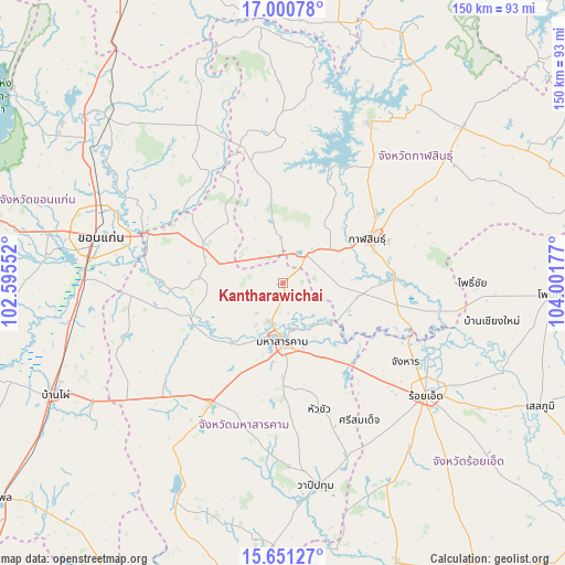
Kantharawichai GPS coordinates[2]
16° 19' 37.884" North, 103° 17' 55.104" East
| Map corner | latitude | longitude |
|---|---|---|
| Upper-left | 17.00078°, | 102.59552° |
| Center: | 16.32719°, | 103.29864° |
| Lower-right: | 15.65127°, | 104.00177° |
| Map W x H: | 150.1×150.1 km | = 93.3×93.3mi |
| max Lat: | 20.43353° ⇑30.2% North |
| Kantharawichai: | 16.32719° |
| min Lat: | ⇓69.8% South 5.77434° |
| min Long | Kantharawichai | max Long |
| 97.93288° | 103.29864° | 105.49506° |
| W 82.6%⇐ | ⇒17.4% E |
Elevation
Elevation of Kantharawichai is 158 m = 518 ft, and this is 32.5 m = 107 ft above average elevation for this country.
| Max E: |
1011 m = 3317 ft | 35.9% |
| Kantharawichai | 158 m 518 ft | |
| Avg. | 125.5 m = 412 ft | |
Min E: |
1 m = 3 ft | 64.1% |
See also: Thailand elevation on elevation.city.
Geographical zone
Kantharawichai is located in North Torrid zone (between Equator and Tropic of Cancer). Distance of this Northern Tropic circle is 790.5 km =491.2 mi to North.| Distance of | km | miles | from Kantharawichai |
|---|---|---|---|
| North Pole | 8191.6 | 5090 | to North |
| Arctic Circle | 5585.8 | 3470.9 | to North |
| Tropic Cancer | 790.5 | 491.2 | to North |
| Equator | 1815.4 | 1128 | to South |


Nearby cities:
15 places around Kantharawichai: (largest is in red/bold)
• Borabue
37.3 km =23.2 mi,  211°
211°
• Changhan
38.7 km =24 mi,  122°
122°
• Chiang Yuen
23.4 km =14.5 mi,  293°
293°
• Chuen Chom
28.5 km =17.7 mi,  332°
332°
• Huai Mek
30 km =18.6 mi,  347°
347°
• Kae Dam
34.9 km =21.7 mi,  164°
164°
• Kalasin
25.1 km =15.6 mi,  62°
62°
• Kamalasai
29.6 km =18.4 mi,  87°
87°
• Khong Chai
18.6 km =11.6 mi,  113°
113°
• Kosum Phisai
26.2 km =16.3 mi,  250°
250°
• Kut Rang
40.3 km =25 mi,  229°
229°
• Maha Sarakham
15.8 km =9.8 mi,  179°
179°
• Nong Kung Si
35.9 km =22.3 mi,  0°
0°
• Sam Sung
33.5 km =20.8 mi,  315°
315°
• Yang Talat
10.9 km =6.8 mi,  42°
42°
Sources, notices
• [Note1] Compared only with cities in Thailand existing in our database
• [Src1] Map data: © OpenStreetMap contributors (CC-BY-SA)
• [Src2] Other city data from geonames.org with taken over terms of usage.
• [Src3] Geographical zone / Annual Mean Temperature by Robert A. Rohde @ Wikipedia
