Charoen Sin geodata
Charoen Sin (Sakon Nakhon) is a seat of a second-order administrative division; located in Thailand in Asia/Bangkok (GMT+7) time zone. In our database, there are 331 cities with bigger population. Compared to other cities in Thailand, 84.9% of cities are located further ↓South; 85% of cities are located further ←West and 72.1% of cities have lower elevation than Charoen Sin. Note1


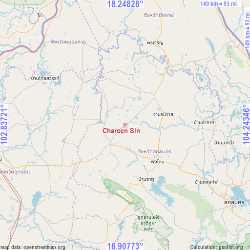
Charoen Sin GPS coordinates[2]
17° 34' 45.3" North, 103° 32' 25.188" East
| Map corner | latitude | longitude |
|---|---|---|
| Upper-left | 18.24828°, | 102.83721° |
| Center: | 17.57925°, | 103.54033° |
| Lower-right: | 16.90773°, | 104.24346° |
| Map W x H: | 149.1×149.1 km | = 92.6×92.6mi |
| max Lat: | 20.43353° ⇑15.1% North |
| Charoen Sin: | 17.57925° |
| min Lat: | ⇓84.9% South 5.77434° |
| min Long | Charoen Sin | max Long |
| 97.93288° | 103.54033° | 105.49506° |
| W 85%⇐ | ⇒15% E |
Elevation
Elevation of Charoen Sin is 175 m = 574 ft, and this is 49.5 m = 162 ft above average elevation for this country.
| Max E: |
1011 m = 3317 ft | 27.9% |
| Charoen Sin | 175 m 574 ft | |
| Avg. | 125.5 m = 412 ft | |
Min E: |
1 m = 3 ft | 72.1% |
See also: Thailand elevation on elevation.city.
Geographical zone
Charoen Sin is located in North Torrid zone (between Equator and Tropic of Cancer). Distance of this Northern Tropic circle is 651.3 km =404.7 mi to North.| Distance of | km | miles | from Charoen Sin |
|---|---|---|---|
| North Pole | 8052.4 | 5003.5 | to North |
| Arctic Circle | 5446.5 | 3384.3 | to North |
| Tropic Cancer | 651.3 | 404.7 | to North |
| Equator | 1954.6 | 1214.5 | to South |


Nearby cities:
15 places around Charoen Sin: (largest is in red/bold)
• Akat Amnuai
46.8 km =29.1 mi,  87°
87°
• Ban Dung
32.6 km =20.3 mi,  294°
294°
• Ban Muang
30.4 km =18.9 mi,  5°
5°
• Ban Nong Wua So
48.2 km =30 mi,  224°
224°
• Chaiwan
45.4 km =28.2 mi,  225°
225°
• Kham Ta Kla
38 km =23.6 mi,  37°
37°
• Nikhom Nam Un
47.9 km =29.8 mi,  156°
156°
• Phang Khon
28.1 km =17.5 mi,  138°
138°
• Phanna Nikhom
41.4 km =25.7 mi,  127°
127°
• Phibun Rak
51.2 km =31.8 mi,  266°
266°
• Sawang Daen Din
14.5 km =9 mi, 217°
• Song Dao
27.9 km =17.3 mi,  194°
194°
• Thung Fon
32 km =19.9 mi,  248°
248°
• Wanon Niwat
23.3 km =14.5 mi,  74°
74°
• Warichaphum
33.4 km =20.8 mi, 161°
Sources, notices
• [Note1] Compared only with cities in Thailand existing in our database
• [Src1] Map data: © OpenStreetMap contributors (CC-BY-SA)
• [Src2] Other city data from geonames.org with taken over terms of usage.
• [Src3] Geographical zone / Annual Mean Temperature by Robert A. Rohde @ Wikipedia
