Ban Phaeng geodata
Ban Phaeng (Nakhon Phanom) is a seat of a second-order administrative division; located in Thailand in Asia/Bangkok (GMT+7) time zone. In our database, there are 331 cities with bigger population. Compared to other cities in Thailand, 88.4% of cities are located further ↓South; 92.9% of cities are located further ←West and 61.8% of cities have lower elevation than Ban Phaeng. Note1


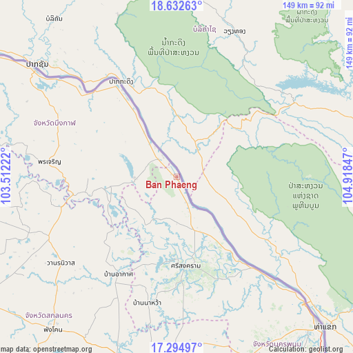
Ban Phaeng GPS coordinates[2]
17° 57' 54.252" North, 104° 12' 55.224" East
| Map corner | latitude | longitude |
|---|---|---|
| Upper-left | 18.63263°, | 103.51222° |
| Center: | 17.96507°, | 104.21534° |
| Lower-right: | 17.29497°, | 104.91847° |
| Map W x H: | 148.7×148.7 km | = 92.4×92.4mi |
| max Lat: | 20.43353° ⇑11.6% North |
| Ban Phaeng: | 17.96507° |
| min Lat: | ⇓88.4% South 5.77434° |
| min Long | Ban Phaeng | max Long |
| 97.93288° | 104.21534° | 105.49506° |
| W 92.9%⇐ | ⇒7.1% E |
Elevation
Elevation of Ban Phaeng is 152 m = 499 ft, and this is 26.5 m = 87 ft above average elevation for this country.
| Max E: |
1011 m = 3317 ft | 38.2% |
| Ban Phaeng | 152 m 499 ft | |
| Avg. | 125.5 m = 412 ft | |
Min E: |
1 m = 3 ft | 61.8% |
See also: Thailand elevation on elevation.city.
Geographical zone
Ban Phaeng is located in North Torrid zone (between Equator and Tropic of Cancer). Distance of this Northern Tropic circle is 608.4 km =378 mi to North.| Distance of | km | miles | from Ban Phaeng |
|---|---|---|---|
| North Pole | 8009.5 | 4976.9 | to North |
| Arctic Circle | 5403.6 | 3357.6 | to North |
| Tropic Cancer | 608.4 | 378 | to North |
| Equator | 1997.5 | 1241.2 | to South |


Nearby cities:
15 places around Ban Phaeng: (largest is in red/bold)
• Akat Amnuai
47.9 km =29.8 mi,  211°
211°
• Ban Muang
69.5 km =43.2 mi,  259°
259°
• Bueng Khong Long
17.8 km =11.1 mi,  268°
268°
• Bung Khla
45.3 km =28.1 mi,  325°
325°
• Kham Ta Kla
50.1 km =31.1 mi, 255°
• Kusuman
71.4 km =44.4 mi,  170°
170°
• Na Thom
24 km =14.9 mi, 213°
• Na Wa
54.2 km =33.7 mi,  192°
192°
• Nathom
23.9 km =14.9 mi, 213°
• Phon Charoen
54 km =33.6 mi,  277°
277°
• Seka
27.8 km =17.3 mi, 261°
• Si Songkhram
37.7 km =23.4 mi, 174°
• Si Wilai
55 km =34.2 mi,  296°
296°
• Tha Uthen
59.3 km =36.8 mi,  136°
136°
• Wanon Niwat
61.3 km =38.1 mi,  233°
233°
Sources, notices
• [Note1] Compared only with cities in Thailand existing in our database
• [Src1] Map data: © OpenStreetMap contributors (CC-BY-SA)
• [Src2] Other city data from geonames.org with taken over terms of usage.
• [Src3] Geographical zone / Annual Mean Temperature by Robert A. Rohde @ Wikipedia
