Tha Tako geodata
Tha Tako (Nakhon Sawan) is a seat of a second-order administrative division; located in Thailand in Asia/Bangkok (GMT+7) time zone. In our database, there are 331 cities with bigger population. Compared to other cities in Thailand, 60.5% of cities are located further ↓South; 59.2% of cities are located further →East and 63.3% of cities have higher elevation than Tha Tako. Note1


Tha Tako GPS coordinates[2]
15° 38' 31.848" North, 100° 28' 42.204" East
| Map corner | latitude | longitude |
|---|---|---|
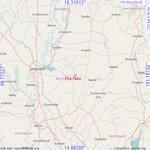
| Upper-left | 16.31813°, | 99.77527° |
| Center: | 15.64218°, | 100.47839° |
| Lower-right: | 14.96399°, | 101.18152° |
| Map W x H: | 150.6×150.6 km | = 93.6×93.6mi |
| max Lat: | 20.43353° ⇑39.5% North |
| Tha Tako: | 15.64218° |
| min Lat: | ⇓60.5% South 5.77434° |
| min Long | Tha Tako | max Long |
| 97.93288° | 100.47839° | 105.49506° |
| W 40.8%⇐ | ⇒59.2% E |
Elevation
Elevation of Tha Tako is 36 m = 118 ft, and this is 89.5 m = 294 ft below average elevation for this country.
| Max E: |
1011 m = 3317 ft | 63.3% |
| Avg. | 125.5 m = 412 ft | |
| Tha Tako | 36 m = 118 ft | |
Min E: |
1 m = 3 ft | 36.7% |
See also: Thailand elevation on elevation.city.
Geographical zone
Tha Tako is located in North Torrid zone (between Equator and Tropic of Cancer). Distance of this Northern Tropic circle is 866.7 km =538.5 mi to North.| Distance of | km | miles | from Tha Tako |
|---|---|---|---|
| North Pole | 8267.8 | 5137.4 | to North |
| Arctic Circle | 5661.9 | 3518.1 | to North |
| Tropic Cancer | 866.7 | 538.5 | to North |
| Equator | 1739.2 | 1080.7 | to South |


Nearby cities:
15 places around Tha Tako: (largest is in red/bold)
• Bang Mun Nak
44.2 km =27.5 mi,  346°
346°
• Bueng Sam Phan
51.6 km =32.1 mi,  66°
66°
• Chumsaeng
33.2 km =20.6 mi,  326°
326°
• Dong Charoen
46.5 km =28.9 mi,  25°
25°
• Kao Liao
48.6 km =30.2 mi,  298°
298°
• Khok Charoen
46.7 km =29 mi,  128°
128°
• Krok Phra
44.6 km =27.7 mi,  257°
257°
• Nakhon Sawan
37.2 km =23.1 mi,  280°
280°
• Nong Bua
27.3 km =17 mi,  24°
24°
• Nong Muang
48 km =29.8 mi,  156°
156°
• Phai Sali
18.9 km =11.7 mi,  104°
104°
• Phayuha Khiri
42.2 km =26.2 mi,  240°
240°
• Pho Thale
55.2 km =34.3 mi,  335°
335°
• Tak Fa
32.6 km =20.3 mi,  176°
176°
• Takhli
44.5 km =27.7 mi,  198°
198°
Sources, notices
• [Note1] Compared only with cities in Thailand existing in our database
• [Src1] Map data: © OpenStreetMap contributors (CC-BY-SA)
• [Src2] Other city data from geonames.org with taken over terms of usage.
• [Src3] Geographical zone / Annual Mean Temperature by Robert A. Rohde @ Wikipedia
