Pho Thale geodata
Pho Thale (Phichit) is a seat of a second-order administrative division; located in Thailand in Asia/Bangkok (GMT+7) time zone. In our database, there are 331 cities with bigger population. Compared to other cities in Thailand, 67.1% of cities are located further ↓South; 65.5% of cities are located further →East and 63.6% of cities have higher elevation than Pho Thale. Note1


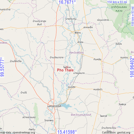
Pho Thale GPS coordinates[2]
16° 5' 33.684" North, 100° 15' 39.204" East
| Map corner | latitude | longitude |
|---|---|---|
| Upper-left | 16.7671°, | 99.55777° |
| Center: | 16.09269°, | 100.26089° |
| Lower-right: | 15.41598°, | 100.96402° |
| Map W x H: | 150.2×150.2 km | = 93.3×93.3mi |
| max Lat: | 20.43353° ⇑32.9% North |
| Pho Thale: | 16.09269° |
| min Lat: | ⇓67.1% South 5.77434° |
| min Long | Pho Thale | max Long |
| 97.93288° | 100.26089° | 105.49506° |
| W 34.5%⇐ | ⇒65.5% E |
Elevation
Elevation of Pho Thale is 35 m = 115 ft, and this is 90.5 m = 297 ft below average elevation for this country.
| Max E: |
1011 m = 3317 ft | 63.6% |
| Avg. | 125.5 m = 412 ft | |
| Pho Thale | 35 m = 115 ft | |
Min E: |
1 m = 3 ft | 36.4% |
See also: Thailand elevation on elevation.city.
Geographical zone
Pho Thale is located in North Torrid zone (between Equator and Tropic of Cancer). Distance of this Northern Tropic circle is 816.6 km =507.4 mi to North.| Distance of | km | miles | from Pho Thale |
|---|---|---|---|
| North Pole | 8217.7 | 5106.2 | to North |
| Arctic Circle | 5611.8 | 3487 | to North |
| Tropic Cancer | 816.6 | 507.4 | to North |
| Equator | 1789.3 | 1111.8 | to South |


Nearby cities:
15 places around Pho Thale: (largest is in red/bold)
• Bang Mun Nak
14.6 km =9.1 mi,  119°
119°
• Banphot Phisai
34.6 km =21.5 mi,  239°
239°
• Bueng Na Rang
16.9 km =10.5 mi,  301°
301°
• Bueng Samakkhi
32.3 km =20.1 mi,  289°
289°
• Chumsaeng
22.9 km =14.2 mi,  167°
167°
• Dong Charoen
43.7 km =27.2 mi,  100°
100°
• Kao Liao
33.2 km =20.6 mi,  215°
215°
• Khanu Woralaksaburi
42.9 km =26.7 mi,  265°
265°
• Nakhon Sawan
45.1 km =28 mi,  197°
197°
• Nong Bua
43 km =26.7 mi,  126°
126°
• Phichit
39.9 km =24.8 mi,  13°
13°
• Sam Ngam
46.4 km =28.8 mi,  352°
352°
• Taphan Hin
22.2 km =13.8 mi,  49°
49°
• Thap Khlo
36.6 km =22.7 mi,  78°
78°
• Wang Sai Phun
44.2 km =27.5 mi,  41°
41°
Sources, notices
• [Note1] Compared only with cities in Thailand existing in our database
• [Src1] Map data: © OpenStreetMap contributors (CC-BY-SA)
• [Src2] Other city data from geonames.org with taken over terms of usage.
• [Src3] Geographical zone / Annual Mean Temperature by Robert A. Rohde @ Wikipedia
