Bang Mun Nak geodata
Bang Mun Nak (Phichit) is a seat of a second-order administrative division; located in Thailand in Asia/Bangkok (GMT+7) time zone. With population of 15,616 people, there are 207 cities with bigger population in this country. Compared to other cities in Thailand, 65.7% of cities are located further ↓South; 62.1% of cities are located further →East and 64.5% of cities have higher elevation than Bang Mun Nak. Note1


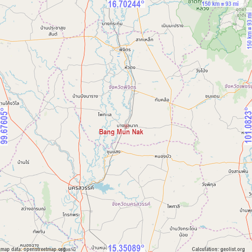
Bang Mun Nak GPS coordinates[2]
16° 1' 40.116" North, 100° 22' 45.012" East
| Map corner | latitude | longitude |
|---|---|---|
| Upper-left | 16.70244°, | 99.67605° |
| Center: | 16.02781°, | 100.37917° |
| Lower-right: | 15.35089°, | 101.0823° |
| Map W x H: | 150.3×150.3 km | = 93.4×93.4mi |
| max Lat: | 20.43353° ⇑34.3% North |
| Bang Mun Nak: | 16.02781° |
| min Lat: | ⇓65.7% South 5.77434° |
| min Long | Bang Mun Nak | max Long |
| 97.93288° | 100.37917° | 105.49506° |
| W 37.9%⇐ | ⇒62.1% E |
Elevation
Elevation of Bang Mun Nak is 33 m = 108 ft, and this is 92.5 m = 303 ft below average elevation for this country.
| Max E: |
1011 m = 3317 ft | 64.5% |
| Avg. | 125.5 m = 412 ft | |
| Bang Mun Nak | 33 m = 108 ft | |
Min E: |
1 m = 3 ft | 35.5% |
See also: Thailand elevation on elevation.city.
Geographical zone
Bang Mun Nak is located in North Torrid zone (between Equator and Tropic of Cancer). Distance of this Northern Tropic circle is 823.8 km =511.9 mi to North.| Distance of | km | miles | from Bang Mun Nak |
|---|---|---|---|
| North Pole | 8224.9 | 5110.7 | to North |
| Arctic Circle | 5619 | 3491.5 | to North |
| Tropic Cancer | 823.8 | 511.9 | to North |
| Equator | 1782.1 | 1107.3 | to South |


Nearby cities:
15 places around Bang Mun Nak: (largest is in red/bold)
• Banphot Phisai
43.7 km =27.2 mi,  256°
256°
• Bueng Na Rang
31.5 km =19.6 mi,  300°
300°
• Bueng Samakkhi
46.6 km =29 mi,  292°
292°
• Chumsaeng
17 km =10.6 mi,  206°
206°
• Dong Charoen
30.3 km =18.8 mi,  91°
91°
• Kao Liao
37.7 km =23.4 mi,  238°
238°
• Nakhon Sawan
44.3 km =27.5 mi,  215°
215°
• Nong Bua
28.6 km =17.8 mi,  129°
129°
• Phichit
46.1 km =28.6 mi,  355°
355°
• Pho Thale
14.6 km =9.1 mi, 299°
• Sak Lek
54 km =33.6 mi,  10°
10°
• Taphan Hin
21.9 km =13.6 mi, 11°
• Tha Tako
44.2 km =27.5 mi,  166°
166°
• Thap Khlo
27.5 km =17.1 mi,  57°
57°
• Wang Sai Phun
43.5 km =27 mi,  22°
22°
Sources, notices
• [Note1] Compared only with cities in Thailand existing in our database
• [Src1] Map data: © OpenStreetMap contributors (CC-BY-SA)
• [Src2] Other city data from geonames.org with taken over terms of usage.
• [Src3] Geographical zone / Annual Mean Temperature by Robert A. Rohde @ Wikipedia
