Borabue geodata
Borabue (Maha Sarakham) is a seat of a second-order administrative division; located in Thailand in Asia/Bangkok (GMT+7) time zone. In our database, there are 331 cities with bigger population. Compared to other cities in Thailand, 66.2% of cities are located further ↓South; 80.6% of cities are located further ←West and 73.9% of cities have lower elevation than Borabue. Note1


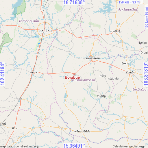
Borabue GPS coordinates[2]
16° 2' 30.444" North, 103° 6' 54.216" East
| Map corner | latitude | longitude |
|---|---|---|
| Upper-left | 16.71638°, | 102.41194° |
| Center: | 16.04179°, | 103.11506° |
| Lower-right: | 15.36491°, | 103.81819° |
| Map W x H: | 150.3×150.3 km | = 93.4×93.4mi |
| max Lat: | 20.43353° ⇑33.8% North |
| Borabue: | 16.04179° |
| min Lat: | ⇓66.2% South 5.77434° |
| min Long | Borabue | max Long |
| 97.93288° | 103.11506° | 105.49506° |
| W 80.6%⇐ | ⇒19.4% E |
Elevation
Elevation of Borabue is 180 m = 591 ft, and this is 54.5 m = 179 ft above average elevation for this country.
| Max E: |
1011 m = 3317 ft | 26.1% |
| Borabue | 180 m 591 ft | |
| Avg. | 125.5 m = 412 ft | |
Min E: |
1 m = 3 ft | 73.9% |
See also: Thailand elevation on elevation.city.
Geographical zone
Borabue is located in North Torrid zone (between Equator and Tropic of Cancer). Distance of this Northern Tropic circle is 822.2 km =510.9 mi to North.| Distance of | km | miles | from Borabue |
|---|---|---|---|
| North Pole | 8223.4 | 5109.8 | to North |
| Arctic Circle | 5617.5 | 3490.6 | to North |
| Tropic Cancer | 822.2 | 510.9 | to North |
| Equator | 1783.7 | 1108.3 | to South |


Nearby cities:
15 places around Borabue: (largest is in red/bold)
• Ban Haet
41.7 km =25.9 mi,  294°
294°
• Ban Phai
41.1 km =25.5 mi,  272°
272°
• Chiang Yuen
41 km =25.5 mi,  357°
357°
• Kae Dam
28.9 km =18 mi,  93°
93°
• Kantharawichai
37.3 km =23.2 mi,  31°
31°
• Khong Chai
44 km =27.3 mi,  56°
56°
• Kosum Phisai
23.5 km =14.6 mi,  347°
347°
• Kut Rang
12.6 km =7.8 mi,  297°
297°
• Maha Sarakham
25.4 km =15.8 mi,  51°
51°
• Na Chueak
29 km =18 mi,  197°
197°
• Na Dun
38.1 km =23.7 mi,  161°
161°
• Pueai Noi
29.3 km =18.2 mi,  229°
229°
• Si Somdet
40.1 km =24.9 mi,  96°
96°
• Wapi Pathum
35.5 km =22.1 mi,  127°
127°
• Yang Si Surat
39.8 km =24.7 mi,  181°
181°
Sources, notices
• [Note1] Compared only with cities in Thailand existing in our database
• [Src1] Map data: © OpenStreetMap contributors (CC-BY-SA)
• [Src2] Other city data from geonames.org with taken over terms of usage.
• [Src3] Geographical zone / Annual Mean Temperature by Robert A. Rohde @ Wikipedia
