Na Dun geodata
Na Dun (Maha Sarakham) is a seat of a second-order administrative division; located in Thailand in Asia/Bangkok (GMT+7) time zone. In our database, there are 331 cities with bigger population. Compared to other cities in Thailand, 61.7% of cities are located further ↓South; 81.9% of cities are located further ←West and 67.5% of cities have lower elevation than Na Dun. Note1


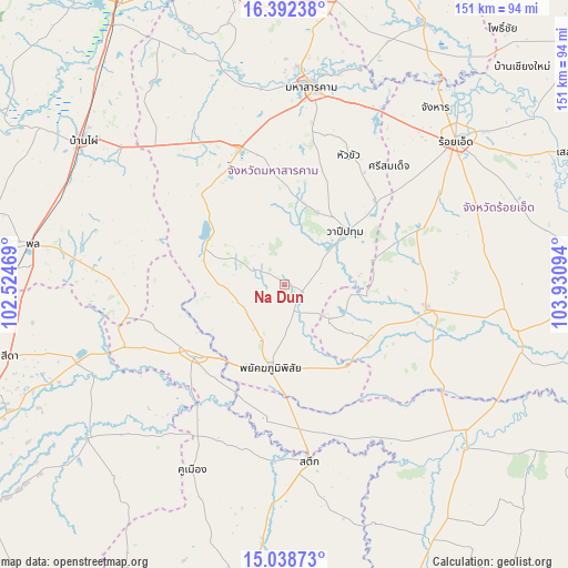
Na Dun GPS coordinates[2]
15° 43' 0.048" North, 103° 13' 40.116" East
| Map corner | latitude | longitude |
|---|---|---|
| Upper-left | 16.39238°, | 102.52469° |
| Center: | 15.71668°, | 103.22781° |
| Lower-right: | 15.03873°, | 103.93094° |
| Map W x H: | 150.5×150.5 km | = 93.5×93.5mi |
| max Lat: | 20.43353° ⇑38.3% North |
| Na Dun: | 15.71668° |
| min Lat: | ⇓61.7% South 5.77434° |
| min Long | Na Dun | max Long |
| 97.93288° | 103.22781° | 105.49506° |
| W 81.9%⇐ | ⇒18.1% E |
Elevation
Elevation of Na Dun is 164 m = 538 ft, and this is 38.5 m = 126 ft above average elevation for this country.
| Max E: |
1011 m = 3317 ft | 32.5% |
| Na Dun | 164 m 538 ft | |
| Avg. | 125.5 m = 412 ft | |
Min E: |
1 m = 3 ft | 67.5% |
See also: Thailand elevation on elevation.city.
Geographical zone
Na Dun is located in North Torrid zone (between Equator and Tropic of Cancer). Distance of this Northern Tropic circle is 858.4 km =533.4 mi to North.| Distance of | km | miles | from Na Dun |
|---|---|---|---|
| North Pole | 8259.5 | 5132.2 | to North |
| Arctic Circle | 5653.6 | 3513 | to North |
| Tropic Cancer | 858.4 | 533.4 | to North |
| Equator | 1747.5 | 1085.8 | to South |


Nearby cities:
15 places around Na Dun: (largest is in red/bold)
• Borabue
38.1 km =23.7 mi,  341°
341°
• Chaturaphak Phiman
38.1 km =23.7 mi,  67°
67°
• Chumphon Buri
44.6 km =27.7 mi,  156°
156°
• Kae Dam
38.1 km =23.7 mi,  26°
26°
• Kaset Wisai
38.7 km =24 mi,  100°
100°
• Khaen Dong
44.7 km =27.8 mi,  193°
193°
• Na Chueak
22.6 km =14 mi,  292°
292°
• Na Pho
30.4 km =18.9 mi,  253°
253°
• Pathum Rat
15.4 km =9.6 mi,  126°
126°
• Phayakkhaphum Phisai
22.6 km =14 mi, 189°
• Phutthaisong
28.7 km =17.8 mi,  229°
229°
• Pueai Noi
38.2 km =23.7 mi,  296°
296°
• Si Somdet
41.9 km =26 mi,  41°
41°
• Wapi Pathum
21.4 km =13.3 mi,  48°
48°
• Yang Si Surat
13.8 km =8.6 mi, 254°
Sources, notices
• [Note1] Compared only with cities in Thailand existing in our database
• [Src1] Map data: © OpenStreetMap contributors (CC-BY-SA)
• [Src2] Other city data from geonames.org with taken over terms of usage.
• [Src3] Geographical zone / Annual Mean Temperature by Robert A. Rohde @ Wikipedia
