Phra Nakhon Si Ayutthaya geodata
Phra Nakhon Si Ayutthaya is a seat of a first-order administrative division; located in Thailand in Asia/Bangkok (GMT+7) time zone. With population of 81,962 people, there are 28 cities with bigger population in this country. Compared to other cities in Thailand, 61.5% of cities are located further ↑North; 54.7% of cities are located further →East and 94.4% of cities have higher elevation than Phra Nakhon Si Ayutthaya. Note1
Current local time in Phra Nakhon Si Ayutthaya:
12:08 PM, FridayDifference from your time zone: hours


Phra Nakhon Si Ayutthaya GPS coordinates[2]
14° 21' 6.012" North, 100° 34' 38.604" East
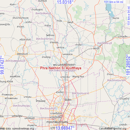
| Map corner | latitude | longitude |
|---|---|---|
| Upper-left | 15.0318°, | 99.87427° |
| Center: | 14.35167°, | 100.57739° |
| Lower-right: | 13.66947°, | 101.28052° |
| Map W x H: | 151.5×151.5 km | = 94.1×94.1mi |
| max Lat: | 20.43353° ⇑61.5% North |
| Phra Nakhon Si Ayutthaya: | 14.35167° |
| min Lat: | ⇓38.5% South 5.77434° |
| min Long | Phra Nakhon Si | max Long |
| 97.93288° | 100.57739° | 105.49506° |
| W 45.3%⇐ | ⇒54.7% E |
Elevation
Elevation of Phra Nakhon Si Ayutthaya is 7 m = 23 ft, and this is 118.5 m = 389 ft below average elevation for this country.
| Max E: |
1011 m = 3317 ft | 94.4% |
| Avg. | 125.5 m = 412 ft | |
| Phra Nakhon Si Ayutthaya | 7 m = 23 ft | |
Min E: |
1 m = 3 ft | 5.6% |
See also: Phra Nakhon Si Ayutthaya elevation on elevation.city.
Geographical zone
Phra Nakhon Si Ayutthaya is located in North Torrid zone (between Equator and Tropic of Cancer). Distance of this Northern Tropic circle is 1010.2 km =627.7 mi to North.| Distance of | km | miles | from Phra Nakhon Si Ayutthaya |
|---|---|---|---|
| North Pole | 8411.3 | 5226.5 | to North |
| Arctic Circle | 5805.4 | 3607.3 | to North |
| Tropic Cancer | 1010.2 | 627.7 | to North |
| Equator | 1595.8 | 991.6 | to South |


Nearby cities:
15 places around Phra Nakhon Si Ayutthaya: (largest is in red/bold)
• Bang Ban
10.2 km =6.3 mi,  284°
284°
• Bang Pa-in
13.8 km =8.6 mi,  180°
180°
• Bang Pahan
12.8 km =8 mi,  344°
344°
• Bang Sai
29.5 km =18.3 mi,  266°
266°
• Don Phut
27.3 km =17 mi,  11°
11°
• Maha Rat
21 km =13 mi, 344°
• Nakhon Luang
12.8 km =8 mi,  15°
15°
• Nong Saeng
27.2 km =16.9 mi,  54°
54°
• Pa Mok
20.7 km =12.9 mi,  317°
317°
• Phachi
19.5 km =12.1 mi,  56°
56°
• Phak Hai
25.2 km =15.7 mi,  297°
297°
• Sena
18.8 km =11.7 mi,  261°
261°
• Tha Ruea
28.8 km =17.9 mi,  33°
33°
• Uthai
10.3 km =6.4 mi,  83°
83°
• Wang Noi
20.3 km =12.6 mi,  132°
132°
In other languages:
- In Spanish: Ayutthaya
- In France: Ayutthaya
- In German: Ayutthaya
- In Italian: Ayutthaya
- In Russian: Аюттхая
Sources, notices
• [Note1] Compared only with cities in Thailand existing in our database
• [Src1] Map data: © OpenStreetMap contributors (CC-BY-SA)
• [Src2] Other city data from geonames.org with taken over terms of usage.
• [Src3] Geographical zone / Annual Mean Temperature by Robert A. Rohde @ Wikipedia
