Phak Hai geodata
Phak Hai (Phra Nakhon Si Ayutthaya) is a seat of a second-order administrative division; located in Thailand in Asia/Bangkok (GMT+7) time zone. With population of 19,386 people, there are 162 cities with bigger population in this country. Compared to other cities in Thailand, 60.2% of cities are located further ↑North; 62.3% of cities are located further →East and 83.5% of cities have higher elevation than Phak Hai. Note1


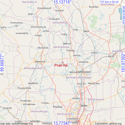
Phak Hai GPS coordinates[2]
14° 27' 26.496" North, 100° 22' 11.604" East
| Map corner | latitude | longitude |
|---|---|---|
| Upper-left | 15.13716°, | 99.66677° |
| Center: | 14.45736°, | 100.36989° |
| Lower-right: | 13.77547°, | 101.07302° |
| Map W x H: | 151.4×151.4 km | = 94.1×94.1mi |
| max Lat: | 20.43353° ⇑60.2% North |
| Phak Hai: | 14.45736° |
| min Lat: | ⇓39.8% South 5.77434° |
| min Long | Phak Hai | max Long |
| 97.93288° | 100.36989° | 105.49506° |
| W 37.7%⇐ | ⇒62.3% E |
Elevation
Elevation of Phak Hai is 11 m = 36 ft, and this is 114.5 m = 376 ft below average elevation for this country.
| Max E: |
1011 m = 3317 ft | 83.5% |
| Avg. | 125.5 m = 412 ft | |
| Phak Hai | 11 m = 36 ft | |
Min E: |
1 m = 3 ft | 16.5% |
See also: Thailand elevation on elevation.city.
Geographical zone
Phak Hai is located in North Torrid zone (between Equator and Tropic of Cancer). Distance of this Northern Tropic circle is 998.4 km =620.4 mi to North.| Distance of | km | miles | from Phak Hai |
|---|---|---|---|
| North Pole | 8399.6 | 5219.3 | to North |
| Arctic Circle | 5793.7 | 3600 | to North |
| Tropic Cancer | 998.4 | 620.4 | to North |
| Equator | 1607.5 | 998.9 | to South |


Nearby cities:
15 places around Phak Hai: (largest is in red/bold)
• Ang Thong
17.1 km =10.6 mi,  31°
31°
• Ban Thai Tan
22.2 km =13.8 mi, 34°
• Bang Ban
15.5 km =9.6 mi,  126°
126°
• Bang Pahan
18.8 km =11.7 mi,  88°
88°
• Bang Pla Ma
23.7 km =14.7 mi,  253°
253°
• Bang Sai
15.4 km =9.6 mi,  207°
207°
• Chaiyo
24.3 km =15.1 mi, 28°
• Maha Rat
18.9 km =11.7 mi,  63°
63°
• Nakhon Luang
25.7 km =16 mi, 88°
• Pa Mok
9.2 km =5.7 mi,  66°
66°
• Pho Thong
23.7 km =14.7 mi,  10°
10°
• Phra Nakhon Si Ayutthaya
25.2 km =15.7 mi,  117°
117°
• Sam Ko
23.3 km =14.5 mi,  315°
315°
• Sena
15 km =9.3 mi,  165°
165°
• Wiset Chaichan
15.6 km =9.7 mi,  347°
347°
Sources, notices
• [Note1] Compared only with cities in Thailand existing in our database
• [Src1] Map data: © OpenStreetMap contributors (CC-BY-SA)
• [Src2] Other city data from geonames.org with taken over terms of usage.
• [Src3] Geographical zone / Annual Mean Temperature by Robert A. Rohde @ Wikipedia
