Sena geodata
Sena (Phra Nakhon Si Ayutthaya) is a seat of a second-order administrative division; located in Thailand in Asia/Bangkok (GMT+7) time zone. In our database, there are 331 cities with bigger population. Compared to other cities in Thailand, 62% of cities are located further ↑North; 61.7% of cities are located further →East and 78.4% of cities have higher elevation than Sena. Note1


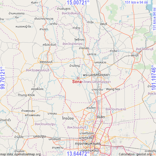
Sena GPS coordinates[2]
14° 19' 37.2" North, 100° 24' 15.588" East
| Map corner | latitude | longitude |
|---|---|---|
| Upper-left | 15.00721°, | 99.70121° |
| Center: | 14.327°, | 100.40433° |
| Lower-right: | 13.64472°, | 101.10746° |
| Map W x H: | 151.5×151.5 km | = 94.1×94.1mi |
| max Lat: | 20.43353° ⇑62% North |
| Sena: | 14.327° |
| min Lat: | ⇓38% South 5.77434° |
| min Long | Sena | max Long |
| 97.93288° | 100.40433° | 105.49506° |
| W 38.3%⇐ | ⇒61.7% E |
Elevation
Elevation of Sena is 13 m = 43 ft, and this is 112.5 m = 369 ft below average elevation for this country.
| Max E: |
1011 m = 3317 ft | 78.4% |
| Avg. | 125.5 m = 412 ft | |
| Sena | 13 m = 43 ft | |
Min E: |
1 m = 3 ft | 21.6% |
See also: Thailand elevation on elevation.city.
Geographical zone
Sena is located in North Torrid zone (between Equator and Tropic of Cancer). Distance of this Northern Tropic circle is 1012.9 km =629.4 mi to North.| Distance of | km | miles | from Sena |
|---|---|---|---|
| North Pole | 8414 | 5228.2 | to North |
| Arctic Circle | 5808.2 | 3609 | to North |
| Tropic Cancer | 1012.9 | 629.4 | to North |
| Equator | 1593 | 989.8 | to South |


Nearby cities:
15 places around Sena: (largest is in red/bold)
• Ang Thong
29.5 km =18.3 mi,  10°
10°
• Bang Ban
10.2 km =6.3 mi,  59°
59°
• Bang Pa-in
21.5 km =13.4 mi,  120°
120°
• Bang Pahan
21.3 km =13.2 mi,  45°
45°
• Bang Pla Ma
27.5 km =17.1 mi,  286°
286°
• Bang Sai
10.9 km =6.8 mi,  274°
274°
• Lat Bua Luang
20.7 km =12.9 mi,  210°
210°
• Maha Rat
26.5 km =16.5 mi,  29°
29°
• Nakhon Luang
26.7 km =16.6 mi, 55°
• Pa Mok
18.7 km =11.6 mi, 14°
• Phak Hai
15 km =9.3 mi,  345°
345°
• Phra Nakhon Si Ayutthaya
18.8 km =11.7 mi,  81°
81°
• Sam Khok
31.7 km =19.7 mi,  156°
156°
• Uthai
29.1 km =18.1 mi, 82°
• Wiset Chaichan
30.6 km =19 mi, 346°
Sources, notices
• [Note1] Compared only with cities in Thailand existing in our database
• [Src1] Map data: © OpenStreetMap contributors (CC-BY-SA)
• [Src2] Other city data from geonames.org with taken over terms of usage.
• [Src3] Geographical zone / Annual Mean Temperature by Robert A. Rohde @ Wikipedia
