Bang Pa-in geodata
Bang Pa-in (Phra Nakhon Si Ayutthaya) is a seat of a second-order administrative division; located in Thailand in Asia/Bangkok (GMT+7) time zone. With population of 20,484 people, there are 153 cities with bigger population in this country. Compared to other cities in Thailand, 62.4% of cities are located further ↑North; 54.9% of cities are located further →East and 91.2% of cities have higher elevation than Bang Pa-in. Note1


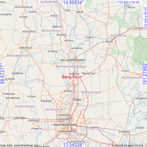
Bang Pa-in GPS coordinates[2]
14° 13' 40.188" North, 100° 34' 33.204" East
| Map corner | latitude | longitude |
|---|---|---|
| Upper-left | 14.90834°, | 99.87277° |
| Center: | 14.22783°, | 100.57589° |
| Lower-right: | 13.54526°, | 101.27902° |
| Map W x H: | 151.6×151.6 km | = 94.2×94.2mi |
| max Lat: | 20.43353° ⇑62.4% North |
| Bang Pa-in: | 14.22783° |
| min Lat: | ⇓37.6% South 5.77434° |
| min Long | Bang Pa-in | max Long |
| 97.93288° | 100.57589° | 105.49506° |
| W 45.1%⇐ | ⇒54.9% E |
Elevation
Elevation of Bang Pa-in is 8 m = 26 ft, and this is 117.5 m = 385 ft below average elevation for this country.
| Max E: |
1011 m = 3317 ft | 91.2% |
| Avg. | 125.5 m = 412 ft | |
| Bang Pa-in | 8 m = 26 ft | |
Min E: |
1 m = 3 ft | 8.8% |
See also: Thailand elevation on elevation.city.
Geographical zone
Bang Pa-in is located in North Torrid zone (between Equator and Tropic of Cancer). Distance of this Northern Tropic circle is 1023.9 km =636.2 mi to North.| Distance of | km | miles | from Bang Pa-in |
|---|---|---|---|
| North Pole | 8425.1 | 5235.1 | to North |
| Arctic Circle | 5819.2 | 3615.9 | to North |
| Tropic Cancer | 1023.9 | 636.2 | to North |
| Equator | 1582 | 983 | to South |


Nearby cities:
15 places around Bang Pa-in: (largest is in red/bold)
• Ban Bang Kadi Pathum Thani
25.6 km =15.9 mi,  186°
186°
• Bang Ban
19 km =11.8 mi,  328°
328°
• Bang Pahan
26.3 km =16.3 mi,  352°
352°
• Khlong Luang
19.6 km =12.2 mi,  157°
157°
• Lat Lum Kaeo
28.1 km =17.5 mi,  221°
221°
• Nakhon Luang
26.4 km =16.4 mi,  7°
7°
• Nong Suea
28.8 km =17.9 mi,  111°
111°
• Pathum Thani
24.3 km =15.1 mi, 191°
• Phachi
29.6 km =18.4 mi,  33°
33°
• Phra Nakhon Si Ayutthaya
13.8 km =8.6 mi,  0°
0°
• Sam Khok
18.9 km =11.7 mi,  197°
197°
• Sena
21.5 km =13.4 mi,  300°
300°
• Thanyaburi
28.6 km =17.8 mi,  143°
143°
• Uthai
18.2 km =11.3 mi, 34°
• Wang Noi
15 km =9.3 mi,  90°
90°
Sources, notices
• [Note1] Compared only with cities in Thailand existing in our database
• [Src1] Map data: © OpenStreetMap contributors (CC-BY-SA)
• [Src2] Other city data from geonames.org with taken over terms of usage.
• [Src3] Geographical zone / Annual Mean Temperature by Robert A. Rohde @ Wikipedia
