Bang Pahan geodata
Bang Pahan (Phra Nakhon Si Ayutthaya) is a seat of a second-order administrative division; located in Thailand in Asia/Bangkok (GMT+7) time zone. In our database, there are 331 cities with bigger population. Compared to other cities in Thailand, 60.1% of cities are located further ↑North; 55.8% of cities are located further →East and 91.2% of cities have higher elevation than Bang Pahan. Note1


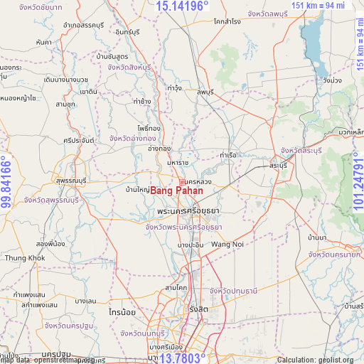
Bang Pahan GPS coordinates[2]
14° 27' 43.812" North, 100° 32' 41.208" East
| Map corner | latitude | longitude |
|---|---|---|
| Upper-left | 15.14196°, | 99.84166° |
| Center: | 14.46217°, | 100.54478° |
| Lower-right: | 13.7803°, | 101.24791° |
| Map W x H: | 151.4×151.4 km | = 94.1×94.1mi |
| max Lat: | 20.43353° ⇑60.1% North |
| Bang Pahan: | 14.46217° |
| min Lat: | ⇓39.9% South 5.77434° |
| min Long | Bang Pahan | max Long |
| 97.93288° | 100.54478° | 105.49506° |
| W 44.2%⇐ | ⇒55.8% E |
Elevation
Elevation of Bang Pahan is 8 m = 26 ft, and this is 117.5 m = 385 ft below average elevation for this country.
| Max E: |
1011 m = 3317 ft | 91.2% |
| Avg. | 125.5 m = 412 ft | |
| Bang Pahan | 8 m = 26 ft | |
Min E: |
1 m = 3 ft | 8.8% |
See also: Thailand elevation on elevation.city.
Geographical zone
Bang Pahan is located in North Torrid zone (between Equator and Tropic of Cancer). Distance of this Northern Tropic circle is 997.9 km =620.1 mi to North.| Distance of | km | miles | from Bang Pahan |
|---|---|---|---|
| North Pole | 8399 | 5218.9 | to North |
| Arctic Circle | 5793.1 | 3599.7 | to North |
| Tropic Cancer | 997.9 | 620.1 | to North |
| Equator | 1608 | 999.2 | to South |


Nearby cities:
15 places around Bang Pahan: (largest is in red/bold)
• Ang Thong
17.2 km =10.7 mi,  324°
324°
• Ban Phraek
20.8 km =12.9 mi,  9°
9°
• Ban Thai Tan
18.8 km =11.7 mi,  340°
340°
• Bang Ban
11.7 km =7.3 mi,  213°
213°
• Chaiyo
21.9 km =13.6 mi, 341°
• Don Phut
17 km =10.6 mi,  31°
31°
• Maha Rat
8.2 km =5.1 mi,  346°
346°
• Nakhon Luang
6.8 km =4.2 mi,  89°
89°
• Pa Mok
10.8 km =6.7 mi,  286°
286°
• Phachi
19.8 km =12.3 mi, 94°
• Phak Hai
18.8 km =11.7 mi,  268°
268°
• Phra Nakhon Si Ayutthaya
12.8 km =8 mi,  164°
164°
• Sena
21.3 km =13.2 mi,  225°
225°
• Tha Ruea
22.7 km =14.1 mi,  59°
59°
• Uthai
17.6 km =10.9 mi,  128°
128°
Sources, notices
• [Note1] Compared only with cities in Thailand existing in our database
• [Src1] Map data: © OpenStreetMap contributors (CC-BY-SA)
• [Src2] Other city data from geonames.org with taken over terms of usage.
• [Src3] Geographical zone / Annual Mean Temperature by Robert A. Rohde @ Wikipedia
