Bang Pla Ma geodata
Bang Pla Ma (Suphan Buri) is a seat of a second-order administrative division; located in Thailand in Asia/Bangkok (GMT+7) time zone. In our database, there are 331 cities with bigger population. Compared to other cities in Thailand, 61.1% of cities are located further ↑North; 67.5% of cities are located further →East and 85.9% of cities have higher elevation than Bang Pla Ma. Note1


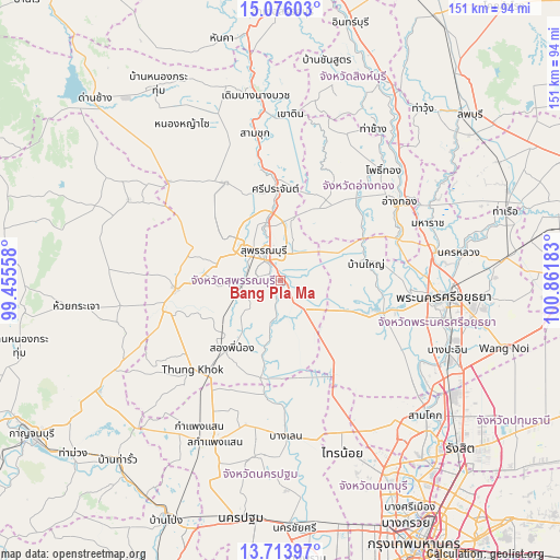
Bang Pla Ma GPS coordinates[2]
14° 23' 45.744" North, 100° 9' 31.32" East
| Map corner | latitude | longitude |
|---|---|---|
| Upper-left | 15.07603°, | 99.45558° |
| Center: | 14.39604°, | 100.1587° |
| Lower-right: | 13.71397°, | 100.86183° |
| Map W x H: | 151.4×151.5 km | = 94.1×94.1mi |
| max Lat: | 20.43353° ⇑61.1% North |
| Bang Pla Ma: | 14.39604° |
| min Lat: | ⇓38.9% South 5.77434° |
| min Long | Bang Pla Ma | max Long |
| 97.93288° | 100.1587° | 105.49506° |
| W 32.5%⇐ | ⇒67.5% E |
Elevation
Elevation of Bang Pla Ma is 10 m = 33 ft, and this is 115.5 m = 379 ft below average elevation for this country.
| Max E: |
1011 m = 3317 ft | 85.9% |
| Avg. | 125.5 m = 412 ft | |
| Bang Pla Ma | 10 m = 33 ft | |
Min E: |
1 m = 3 ft | 14.1% |
See also: Thailand elevation on elevation.city.
Geographical zone
Bang Pla Ma is located in North Torrid zone (between Equator and Tropic of Cancer). Distance of this Northern Tropic circle is 1005.2 km =624.6 mi to North.| Distance of | km | miles | from Bang Pla Ma |
|---|---|---|---|
| North Pole | 8406.4 | 5223.5 | to North |
| Arctic Circle | 5800.5 | 3604.3 | to North |
| Tropic Cancer | 1005.2 | 624.6 | to North |
| Equator | 1600.7 | 994.6 | to South |


Nearby cities:
15 places around Bang Pla Ma: (largest is in red/bold)
• Ang Thong
38.2 km =23.7 mi,  55°
55°
• Ban Sam Chuk
39.1 km =24.3 mi,  349°
349°
• Bang Ban
35.3 km =21.9 mi,  93°
93°
• Bang Sai
17.1 km =10.6 mi,  113°
113°
• Don Chedi
30.4 km =18.9 mi,  330°
330°
• Lat Bua Luang
30.2 km =18.8 mi,  147°
147°
• Pa Mok
32.9 km =20.4 mi,  71°
71°
• Phak Hai
23.7 km =14.7 mi, 73°
• Sam Ko
24.4 km =15.2 mi,  15°
15°
• Sena
27.5 km =17.1 mi, 106°
• Si Prachan
24.9 km =15.5 mi,  356°
356°
• Song Phi Nong
24.2 km =15 mi,  217°
217°
• Suphan Buri
9.5 km =5.9 mi,  335°
335°
• U Thong
28.8 km =17.9 mi,  265°
265°
• Wiset Chaichan
29.3 km =18.2 mi,  41°
41°
Sources, notices
• [Note1] Compared only with cities in Thailand existing in our database
• [Src1] Map data: © OpenStreetMap contributors (CC-BY-SA)
• [Src2] Other city data from geonames.org with taken over terms of usage.
• [Src3] Geographical zone / Annual Mean Temperature by Robert A. Rohde @ Wikipedia
