Maha Sarakham geodata
Maha Sarakham is a seat of a first-order administrative division; located in Thailand in Asia/Bangkok (GMT+7) time zone. With population of 51,584 people, there are 52 cities with bigger population in this country. Compared to other cities in Thailand, 68.1% of cities are located further ↓South; 82.8% of cities are located further ←West and 62.6% of cities have lower elevation than Maha Sarakham. Note1


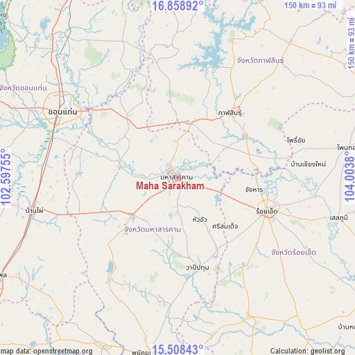
Maha Sarakham GPS coordinates[2]
16° 11' 5.388" North, 103° 18' 2.412" East
| Map corner | latitude | longitude |
|---|---|---|
| Upper-left | 16.85892°, | 102.59755° |
| Center: | 16.18483°, | 103.30067° |
| Lower-right: | 15.50843°, | 104.0038° |
| Map W x H: | 150.2×150.2 km | = 93.3×93.3mi |
| max Lat: | 20.43353° ⇑31.9% North |
| Maha Sarakham: | 16.18483° |
| min Lat: | ⇓68.1% South 5.77434° |
| min Long | Maha Sarakham | max Long |
| 97.93288° | 103.30067° | 105.49506° |
| W 82.8%⇐ | ⇒17.2% E |
Elevation
Elevation of Maha Sarakham is 155 m = 509 ft, and this is 29.5 m = 97 ft above average elevation for this country.
| Max E: |
1011 m = 3317 ft | 37.4% |
| Maha Sarakham | 155 m 509 ft | |
| Avg. | 125.5 m = 412 ft | |
Min E: |
1 m = 3 ft | 62.6% |
See also: Maha Sarakham elevation on elevation.city.
Geographical zone
Maha Sarakham is located in North Torrid zone (between Equator and Tropic of Cancer). Distance of this Northern Tropic circle is 806.3 km =501 mi to North.| Distance of | km | miles | from Maha Sarakham |
|---|---|---|---|
| North Pole | 8207.5 | 5099.9 | to North |
| Arctic Circle | 5601.6 | 3480.7 | to North |
| Tropic Cancer | 806.3 | 501 | to North |
| Equator | 1799.6 | 1118.2 | to South |


Nearby cities:
15 places around Maha Sarakham: (largest is in red/bold)
• Borabue
25.4 km =15.8 mi,  231°
231°
• Changhan
32.8 km =20.4 mi,  98°
98°
• Chiang Yuen
33.1 km =20.6 mi,  319°
319°
• Chuen Chom
43.2 km =26.8 mi,  342°
342°
• Kae Dam
20 km =12.4 mi,  153°
153°
• Kalasin
35.3 km =21.9 mi,  38°
38°
• Kamalasai
34 km =21.1 mi,  59°
59°
• Kantharawichai
15.8 km =9.8 mi,  359°
359°
• Khong Chai
18.8 km =11.7 mi, 63°
• Kosum Phisai
25.9 km =16.1 mi,  285°
285°
• Kut Rang
32.6 km =20.3 mi,  251°
251°
• Roi Et
40.3 km =25 mi,  110°
110°
• Si Somdet
28.8 km =17.9 mi,  136°
136°
• Wapi Pathum
38.6 km =24 mi,  167°
167°
• Yang Talat
25 km =15.5 mi,  16°
16°
Sources, notices
• [Note1] Compared only with cities in Thailand existing in our database
• [Src1] Map data: © OpenStreetMap contributors (CC-BY-SA)
• [Src2] Other city data from geonames.org with taken over terms of usage.
• [Src3] Geographical zone / Annual Mean Temperature by Robert A. Rohde @ Wikipedia
