Wapi Pathum geodata
Wapi Pathum (Maha Sarakham) is a seat of a second-order administrative division; located in Thailand in Asia/Bangkok (GMT+7) time zone. With population of 10,198 people, there are 282 cities with bigger population in this country. Compared to other cities in Thailand, 63.5% of cities are located further ↓South; 83.6% of cities are located further ←West and 59.5% of cities have lower elevation than Wapi Pathum. Note1


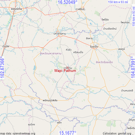
Wapi Pathum GPS coordinates[2]
15° 50' 42.828" North, 103° 22' 36.408" East
| Map corner | latitude | longitude |
|---|---|---|
| Upper-left | 16.52049°, | 102.67366° |
| Center: | 15.84523°, | 103.37678° |
| Lower-right: | 15.1677°, | 104.07991° |
| Map W x H: | 150.4×150.4 km | = 93.5×93.5mi |
| max Lat: | 20.43353° ⇑36.5% North |
| Wapi Pathum: | 15.84523° |
| min Lat: | ⇓63.5% South 5.77434° |
| min Long | Wapi Pathum | max Long |
| 97.93288° | 103.37678° | 105.49506° |
| W 83.6%⇐ | ⇒16.4% E |
Elevation
Elevation of Wapi Pathum is 147 m = 482 ft, and this is 21.5 m = 71 ft above average elevation for this country.
| Max E: |
1011 m = 3317 ft | 40.5% |
| Wapi Pathum | 147 m 482 ft | |
| Avg. | 125.5 m = 412 ft | |
Min E: |
1 m = 3 ft | 59.5% |
See also: Thailand elevation on elevation.city.
Geographical zone
Wapi Pathum is located in North Torrid zone (between Equator and Tropic of Cancer). Distance of this Northern Tropic circle is 844.1 km =524.5 mi to North.| Distance of | km | miles | from Wapi Pathum |
|---|---|---|---|
| North Pole | 8245.2 | 5123.3 | to North |
| Arctic Circle | 5639.3 | 3504.1 | to North |
| Tropic Cancer | 844.1 | 524.5 | to North |
| Equator | 1761.8 | 1094.7 | to South |


Nearby cities:
15 places around Wapi Pathum: (largest is in red/bold)
• Borabue
35.5 km =22.1 mi,  307°
307°
• Changhan
40.7 km =25.3 mi,  36°
36°
• Chaturaphak Phiman
19.3 km =12 mi,  89°
89°
• Kae Dam
19.9 km =12.4 mi,  2°
2°
• Kaset Wisai
30.6 km =19 mi,  133°
133°
• Maha Sarakham
38.6 km =24 mi,  347°
347°
• Mueang Suang
37.7 km =23.4 mi, 93°
• Na Chueak
37.3 km =23.2 mi,  261°
261°
• Na Dun
21.4 km =13.3 mi,  228°
228°
• Pathum Rat
23.7 km =14.7 mi,  188°
188°
• Phayakkhaphum Phisai
41.5 km =25.8 mi,  208°
208°
• Roi Et
37.8 km =23.5 mi,  51°
51°
• Si Somdet
20.7 km =12.9 mi,  34°
34°
• Thawat Buri
45 km =28 mi,  61°
61°
• Yang Si Surat
34.4 km =21.4 mi,  238°
238°
Sources, notices
• [Note1] Compared only with cities in Thailand existing in our database
• [Src1] Map data: © OpenStreetMap contributors (CC-BY-SA)
• [Src2] Other city data from geonames.org with taken over terms of usage.
• [Src3] Geographical zone / Annual Mean Temperature by Robert A. Rohde @ Wikipedia
