Kut Khaopun geodata
Kut Khaopun (Changwat Ubon Ratchathani) is a seat of a second-order administrative division; located in Thailand in Asia/Bangkok (GMT+7) time zone. In our database, there are 331 cities with bigger population. Compared to other cities in Thailand, 62.3% of cities are located further ↓South; 98.4% of cities are located further ←West and 62.6% of cities have lower elevation than Kut Khaopun. Note1


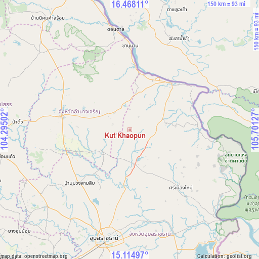
Kut Khaopun GPS coordinates[2]
15° 47' 33.612" North, 104° 59' 53.304" East
| Map corner | latitude | longitude |
|---|---|---|
| Upper-left | 16.46811°, | 104.29502° |
| Center: | 15.79267°, | 104.99814° |
| Lower-right: | 15.11497°, | 105.70127° |
| Map W x H: | 150.5×150.5 km | = 93.5×93.5mi |
| max Lat: | 20.43353° ⇑37.7% North |
| Kut Khaopun: | 15.79267° |
| min Lat: | ⇓62.3% South 5.77434° |
| min Long | Kut Khaopun | max Long |
| 97.93288° | 104.99814° | 105.49506° |
| W 98.4%⇐ | ⇒1.6% E |
Elevation
Elevation of Kut Khaopun is 155 m = 509 ft, and this is 29.5 m = 97 ft above average elevation for this country.
| Max E: |
1011 m = 3317 ft | 37.4% |
| Kut Khaopun | 155 m 509 ft | |
| Avg. | 125.5 m = 412 ft | |
Min E: |
1 m = 3 ft | 62.6% |
See also: Thailand elevation on elevation.city.
Geographical zone
Kut Khaopun is located in North Torrid zone (between Equator and Tropic of Cancer). Distance of this Northern Tropic circle is 849.9 km =528.1 mi to North.| Distance of | km | miles | from Kut Khaopun |
|---|---|---|---|
| North Pole | 8251.1 | 5127 | to North |
| Arctic Circle | 5645.2 | 3507.8 | to North |
| Tropic Cancer | 849.9 | 528.1 | to North |
| Equator | 1756 | 1091.1 | to South |


Nearby cities:
15 places around Kut Khaopun: (largest is in red/bold)
• Amnat Charoen
40.2 km =25 mi,  280°
280°
• Chanuman
49 km =30.4 mi,  0°
0°
• Don Mot Daeng
46.1 km =28.6 mi,  176°
176°
• Hua Taphan
55.2 km =34.3 mi,  258°
258°
• Khemarat
36.4 km =22.6 mi,  40°
40°
• Lao Suea Kok
42.4 km =26.3 mi,  190°
190°
• Lue Amnat
39 km =24.2 mi,  253°
253°
• Muang Sam Sip
42.6 km =26.5 mi,  223°
223°
• Na Tan
33.6 km =20.9 mi,  69°
69°
• Pathum Ratchawongsa
14.8 km =9.2 mi,  318°
318°
• Phana
20.4 km =12.7 mi,  232°
232°
• Pho Sai
28.3 km =17.6 mi,  82°
82°
• Senangkhanikhom
44.6 km =27.7 mi,  308°
308°
• Si Mueang Mai
44.7 km =27.8 mi,  138°
138°
• Trakan Phut Phon
20.3 km =12.6 mi,  172°
172°
Sources, notices
• [Note1] Compared only with cities in Thailand existing in our database
• [Src1] Map data: © OpenStreetMap contributors (CC-BY-SA)
• [Src2] Other city data from geonames.org with taken over terms of usage.
• [Src3] Geographical zone / Annual Mean Temperature by Robert A. Rohde @ Wikipedia
