Lue Amnat geodata
Lue Amnat (Amnat Charoen) is a seat of a second-order administrative division; located in Thailand in Asia/Bangkok (GMT+7) time zone. In our database, there are 331 cities with bigger population. Compared to other cities in Thailand, 61.4% of cities are located further ↓South; 96.2% of cities are located further ←West and 52.6% of cities have lower elevation than Lue Amnat. Note1


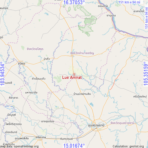
Lue Amnat GPS coordinates[2]
15° 41' 41.136" North, 104° 38' 54.456" East
| Map corner | latitude | longitude |
|---|---|---|
| Upper-left | 16.37053°, | 103.94534° |
| Center: | 15.69476°, | 104.64846° |
| Lower-right: | 15.01674°, | 105.35159° |
| Map W x H: | 150.5×150.5 km | = 93.5×93.5mi |
| max Lat: | 20.43353° ⇑38.6% North |
| Lue Amnat: | 15.69476° |
| min Lat: | ⇓61.4% South 5.77434° |
| min Long | Lue Amnat | max Long |
| 97.93288° | 104.64846° | 105.49506° |
| W 96.2%⇐ | ⇒3.8% E |
Elevation
Elevation of Lue Amnat is 128 m = 420 ft, and this is 2.5 m = 8 ft above average elevation for this country.
| Max E: |
1011 m = 3317 ft | 47.4% |
| Lue Amnat | 128 m 420 ft | |
| Avg. | 125.5 m = 412 ft | |
Min E: |
1 m = 3 ft | 52.6% |
See also: Thailand elevation on elevation.city.
Geographical zone
Lue Amnat is located in North Torrid zone (between Equator and Tropic of Cancer). Distance of this Northern Tropic circle is 860.8 km =534.9 mi to North.| Distance of | km | miles | from Lue Amnat |
|---|---|---|---|
| North Pole | 8262 | 5133.8 | to North |
| Arctic Circle | 5656.1 | 3514.5 | to North |
| Tropic Cancer | 860.8 | 534.9 | to North |
| Equator | 1745.1 | 1084.4 | to South |


Nearby cities:
15 places around Lue Amnat: (largest is in red/bold)
• Amnat Charoen
18.3 km =11.4 mi,  353°
353°
• Hua Taphan
16.8 km =10.4 mi,  270°
270°
• Kham Khuean Kaeo
36.7 km =22.8 mi,  262°
262°
• Kho Wang
48.1 km =29.9 mi,  221°
221°
• Khueang Nai
35.5 km =22.1 mi,  197°
197°
• Kut Khaopun
39 km =24.2 mi,  73°
73°
• Lao Suea Kok
42.6 km =26.5 mi,  136°
136°
• Maha Chana Chai
47.6 km =29.6 mi,  247°
247°
• Muang Sam Sip
21.8 km =13.5 mi,  157°
157°
• Pa Tio
31.9 km =19.8 mi,  298°
298°
• Pathum Ratchawongsa
35.2 km =21.9 mi,  51°
51°
• Phana
21.2 km =13.2 mi,  93°
93°
• Senangkhanikhom
38.4 km =23.9 mi,  3°
3°
• Thai Charoen
46.9 km =29.1 mi,  331°
331°
• Trakan Phut Phon
41 km =25.5 mi,  103°
103°
Sources, notices
• [Note1] Compared only with cities in Thailand existing in our database
• [Src1] Map data: © OpenStreetMap contributors (CC-BY-SA)
• [Src2] Other city data from geonames.org with taken over terms of usage.
• [Src3] Geographical zone / Annual Mean Temperature by Robert A. Rohde @ Wikipedia
