Pathum Ratchawongsa geodata
Pathum Ratchawongsa (Amnat Charoen) is a seat of a second-order administrative division; located in Thailand in Asia/Bangkok (GMT+7) time zone. In our database, there are 331 cities with bigger population. Compared to other cities in Thailand, 64.2% of cities are located further ↓South; 97.9% of cities are located further ←West and 74.9% of cities have lower elevation than Pathum Ratchawongsa. Note1


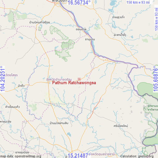
Pathum Ratchawongsa GPS coordinates[2]
15° 53' 32.064" North, 104° 54' 20.268" East
| Map corner | latitude | longitude |
|---|---|---|
| Upper-left | 16.56734°, | 104.20251° |
| Center: | 15.89224°, | 104.90563° |
| Lower-right: | 15.21487°, | 105.60876° |
| Map W x H: | 150.4×150.4 km | = 93.5×93.5mi |
| max Lat: | 20.43353° ⇑35.8% North |
| Pathum Ratchawongsa: | 15.89224° |
| min Lat: | ⇓64.2% South 5.77434° |
| min Long | Pathum Ratchawo | max Long |
| 97.93288° | 104.90563° | 105.49506° |
| W 97.9%⇐ | ⇒2.1% E |
Elevation
Elevation of Pathum Ratchawongsa is 182 m = 597 ft, and this is 56.5 m = 185 ft above average elevation for this country.
| Max E: |
1011 m = 3317 ft | 25.1% |
| Pathum Ratchawongsa | 182 m 597 ft | |
| Avg. | 125.5 m = 412 ft | |
Min E: |
1 m = 3 ft | 74.9% |
See also: Thailand elevation on elevation.city.
Geographical zone
Pathum Ratchawongsa is located in North Torrid zone (between Equator and Tropic of Cancer). Distance of this Northern Tropic circle is 838.9 km =521.3 mi to North.| Distance of | km | miles | from Pathum Ratchawongsa |
|---|---|---|---|
| North Pole | 8240 | 5120.1 | to North |
| Arctic Circle | 5634.1 | 3500.9 | to North |
| Tropic Cancer | 838.9 | 521.3 | to North |
| Equator | 1767.1 | 1098 | to South |


Nearby cities:
15 places around Pathum Ratchawongsa: (largest is in red/bold)
• Amnat Charoen
29.8 km =18.5 mi,  262°
262°
• Chanuman
39.3 km =24.4 mi,  14°
14°
• Don Tan
47.3 km =29.4 mi,  1°
1°
• Hua Taphan
49.3 km =30.6 mi,  243°
243°
• Khemarat
37.4 km =23.2 mi,  63°
63°
• Kut Khaopun
14.8 km =9.2 mi,  138°
138°
• Lao Suea Kok
52.7 km =32.7 mi,  177°
177°
• Loeng Nok Tha
51.3 km =31.9 mi,  313°
313°
• Lue Amnat
35.2 km =21.9 mi,  231°
231°
• Muang Sam Sip
46.4 km =28.8 mi,  204°
204°
• Na Tan
41.4 km =25.7 mi,  89°
89°
• Phana
24.2 km =15 mi, 195°
• Pho Sai
38.7 km =24 mi,  100°
100°
• Senangkhanikhom
30.1 km =18.7 mi,  302°
302°
• Trakan Phut Phon
33.6 km =20.9 mi,  158°
158°
Sources, notices
• [Note1] Compared only with cities in Thailand existing in our database
• [Src1] Map data: © OpenStreetMap contributors (CC-BY-SA)
• [Src2] Other city data from geonames.org with taken over terms of usage.
• [Src3] Geographical zone / Annual Mean Temperature by Robert A. Rohde @ Wikipedia
