Senangkhanikhom geodata
Senangkhanikhom (Amnat Charoen) is a seat of a second-order administrative division; located in Thailand in Asia/Bangkok (GMT+7) time zone. In our database, there are 331 cities with bigger population. Compared to other cities in Thailand, 66.1% of cities are located further ↓South; 96.4% of cities are located further ←West and 67.1% of cities have lower elevation than Senangkhanikhom. Note1


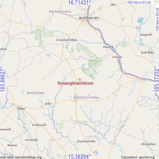
Senangkhanikhom GPS coordinates[2]
16° 2' 22.992" North, 104° 40' 9.804" East
| Map corner | latitude | longitude |
|---|---|---|
| Upper-left | 16.71431°, | 103.96627° |
| Center: | 16.03972°, | 104.66939° |
| Lower-right: | 15.36284°, | 105.37252° |
| Map W x H: | 150.3×150.3 km | = 93.4×93.4mi |
| max Lat: | 20.43353° ⇑33.9% North |
| Senangkhanikhom: | 16.03972° |
| min Lat: | ⇓66.1% South 5.77434° |
| min Long | Senangkhanikhom | max Long |
| 97.93288° | 104.66939° | 105.49506° |
| W 96.4%⇐ | ⇒3.6% E |
Elevation
Elevation of Senangkhanikhom is 163 m = 535 ft, and this is 37.5 m = 123 ft above average elevation for this country.
| Max E: |
1011 m = 3317 ft | 32.9% |
| Senangkhanikhom | 163 m 535 ft | |
| Avg. | 125.5 m = 412 ft | |
Min E: |
1 m = 3 ft | 67.1% |
See also: Thailand elevation on elevation.city.
Geographical zone
Senangkhanikhom is located in North Torrid zone (between Equator and Tropic of Cancer). Distance of this Northern Tropic circle is 822.5 km =511.1 mi to North.| Distance of | km | miles | from Senangkhanikhom |
|---|---|---|---|
| North Pole | 8223.6 | 5109.9 | to North |
| Arctic Circle | 5617.7 | 3490.7 | to North |
| Tropic Cancer | 822.5 | 511.1 | to North |
| Equator | 1783.4 | 1108.2 | to South |


Nearby cities:
15 places around Senangkhanikhom: (largest is in red/bold)
• Amnat Charoen
20.6 km =12.8 mi,  192°
192°
• Chanuman
41.4 km =25.7 mi,  58°
58°
• Don Tan
40.8 km =25.4 mi,  40°
40°
• Hua Taphan
42.6 km =26.5 mi,  206°
206°
• Kut Chum
35.3 km =21.9 mi,  268°
268°
• Kut Khaopun
44.6 km =27.7 mi,  128°
128°
• Loeng Nok Tha
22.3 km =13.9 mi,  326°
326°
• Lue Amnat
38.4 km =23.9 mi,  183°
183°
• Mukdahan
56.5 km =35.1 mi,  5°
5°
• Nikhom Kham Soi
39 km =24.2 mi,  341°
341°
• Pa Tio
38 km =23.6 mi,  232°
232°
• Pathum Ratchawongsa
30.1 km =18.7 mi,  122°
122°
• Phana
44 km =27.3 mi,  154°
154°
• Sai Mun
50.4 km =31.3 mi,  257°
257°
• Thai Charoen
24.7 km =15.3 mi,  276°
276°
Sources, notices
• [Note1] Compared only with cities in Thailand existing in our database
• [Src1] Map data: © OpenStreetMap contributors (CC-BY-SA)
• [Src2] Other city data from geonames.org with taken over terms of usage.
• [Src3] Geographical zone / Annual Mean Temperature by Robert A. Rohde @ Wikipedia
