Phra Phutthabat geodata
Phra Phutthabat (Sara Buri) is a seat of a second-order administrative division; located in Thailand in Asia/Bangkok (GMT+7) time zone. With population of 57,008 people, there are 45 cities with bigger population in this country. Compared to other cities in Thailand, 55.2% of cities are located further ↑North; 50.6% of cities are located further ←West and 57.9% of cities have higher elevation than Phra Phutthabat. Note1


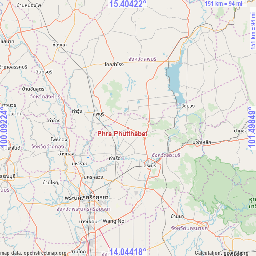
Phra Phutthabat GPS coordinates[2]
14° 43' 30.936" North, 100° 47' 43.296" East
| Map corner | latitude | longitude |
|---|---|---|
| Upper-left | 15.40422°, | 100.09224° |
| Center: | 14.72526°, | 100.79536° |
| Lower-right: | 14.04418°, | 101.49849° |
| Map W x H: | 151.2×151.2 km | = 94×94mi |
| max Lat: | 20.43353° ⇑55.2% North |
| Phra Phutthabat: | 14.72526° |
| min Lat: | ⇓44.8% South 5.77434° |
| min Long | Phra Phutthabat | max Long |
| 97.93288° | 100.79536° | 105.49506° |
| W 50.6%⇐ | ⇒49.4% E |
Elevation
Elevation of Phra Phutthabat is 50 m = 164 ft, and this is 75.5 m = 248 ft below average elevation for this country.
| Max E: |
1011 m = 3317 ft | 57.9% |
| Avg. | 125.5 m = 412 ft | |
| Phra Phutthabat | 50 m = 164 ft | |
Min E: |
1 m = 3 ft | 42.1% |
See also: Phra Phutthabat elevation on elevation.city.
Geographical zone
Phra Phutthabat is located in North Torrid zone (between Equator and Tropic of Cancer). Distance of this Northern Tropic circle is 968.6 km =601.9 mi to North.| Distance of | km | miles | from Phra Phutthabat |
|---|---|---|---|
| North Pole | 8369.8 | 5200.8 | to North |
| Arctic Circle | 5763.9 | 3581.5 | to North |
| Tropic Cancer | 968.6 | 601.9 | to North |
| Equator | 1637.3 | 1017.4 | to South |


Nearby cities:
15 places around Phra Phutthabat: (largest is in red/bold)
• Ban Mo
14.2 km =8.8 mi,  210°
210°
• Ban Phraek
25.1 km =15.6 mi,  249°
249°
• Ban Thai Tan
35.1 km =21.8 mi, 250°
• Chaloem Phra Kiat
17.5 km =10.9 mi,  136°
136°
• Don Phut
23.3 km =14.5 mi,  230°
230°
• Kaeng Khoi
26.7 km =16.6 mi,  125°
125°
• Lop Buri
17.2 km =10.7 mi,  298°
298°
• Nong Don
10.3 km =6.4 mi,  244°
244°
• Nong Saeng
26 km =16.2 mi,  182°
182°
• Phachi
31.5 km =19.6 mi,  193°
193°
• Phatthana Nikhom
25 km =15.5 mi,  54°
54°
• Sao Hai
20.1 km =12.5 mi,  164°
164°
• Saraburi
25 km =15.5 mi,  148°
148°
• Tha Ruea
19.1 km =11.9 mi,  203°
203°
• Tha Wung
32.8 km =20.4 mi,  286°
286°
Sources, notices
• [Note1] Compared only with cities in Thailand existing in our database
• [Src1] Map data: © OpenStreetMap contributors (CC-BY-SA)
• [Src2] Other city data from geonames.org with taken over terms of usage.
• [Src3] Geographical zone / Annual Mean Temperature by Robert A. Rohde @ Wikipedia
