Nong Don geodata
Nong Don (Sara Buri) is a seat of a second-order administrative division; located in Thailand in Asia/Bangkok (GMT+7) time zone. In our database, there are 331 cities with bigger population. Compared to other cities in Thailand, 55.8% of cities are located further ↑North; 51.4% of cities are located further →East and 83.5% of cities have higher elevation than Nong Don. Note1


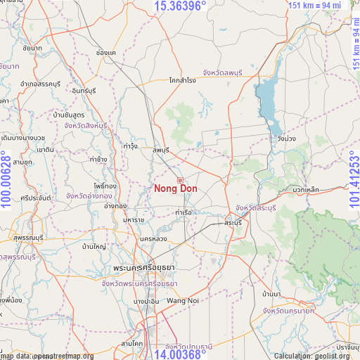
Nong Don GPS coordinates[2]
14° 41' 5.568" North, 100° 42' 33.84" East
| Map corner | latitude | longitude |
|---|---|---|
| Upper-left | 15.36396°, | 100.00628° |
| Center: | 14.68488°, | 100.7094° |
| Lower-right: | 14.00368°, | 101.41253° |
| Map W x H: | 151.2×151.3 km | = 94×94mi |
| max Lat: | 20.43353° ⇑55.8% North |
| Nong Don: | 14.68488° |
| min Lat: | ⇓44.2% South 5.77434° |
| min Long | Nong Don | max Long |
| 97.93288° | 100.7094° | 105.49506° |
| W 48.6%⇐ | ⇒51.4% E |
Elevation
Elevation of Nong Don is 11 m = 36 ft, and this is 114.5 m = 376 ft below average elevation for this country.
| Max E: |
1011 m = 3317 ft | 83.5% |
| Avg. | 125.5 m = 412 ft | |
| Nong Don | 11 m = 36 ft | |
Min E: |
1 m = 3 ft | 16.5% |
See also: Thailand elevation on elevation.city.
Geographical zone
Nong Don is located in North Torrid zone (between Equator and Tropic of Cancer). Distance of this Northern Tropic circle is 973.1 km =604.7 mi to North.| Distance of | km | miles | from Nong Don |
|---|---|---|---|
| North Pole | 8374.3 | 5203.5 | to North |
| Arctic Circle | 5768.4 | 3584.3 | to North |
| Tropic Cancer | 973.1 | 604.7 | to North |
| Equator | 1632.8 | 1014.6 | to South |


Nearby cities:
15 places around Nong Don: (largest is in red/bold)
• Ban Mo
8 km =5 mi,  165°
165°
• Ban Phraek
14.9 km =9.3 mi,  253°
253°
• Ban Thai Tan
24.9 km =15.5 mi, 253°
• Chaiyo
25.1 km =15.6 mi,  260°
260°
• Chaiyo
25.9 km =16.1 mi,  267°
267°
• Chaloem Phra Kiat
22.9 km =14.2 mi,  110°
110°
• Don Phut
13.5 km =8.4 mi,  220°
220°
• Lop Buri
13.9 km =8.6 mi,  334°
334°
• Maha Rat
25.9 km =16.1 mi,  229°
229°
• Nong Saeng
22.9 km =14.2 mi,  159°
159°
• Phachi
26.3 km =16.3 mi,  175°
175°
• Phra Phutthabat
10.3 km =6.4 mi,  64°
64°
• Sao Hai
20.8 km =12.9 mi,  135°
135°
• Tha Ruea
13.2 km =8.2 mi, 172°
• Tha Wung
26.2 km =16.3 mi,  302°
302°
Sources, notices
• [Note1] Compared only with cities in Thailand existing in our database
• [Src1] Map data: © OpenStreetMap contributors (CC-BY-SA)
• [Src2] Other city data from geonames.org with taken over terms of usage.
• [Src3] Geographical zone / Annual Mean Temperature by Robert A. Rohde @ Wikipedia
