Chiang Khong geodata
Chiang Khong (Chiang Rai) is a seat of a second-order administrative division; located in Thailand in Asia/Bangkok (GMT+7) time zone. With population of 14,505 people, there are 224 cities with bigger population in this country. Compared to other cities in Thailand, 99.7% of cities are located further ↓South; 61.6% of cities are located further →East and 93.7% of cities have lower elevation than Chiang Khong. Note1


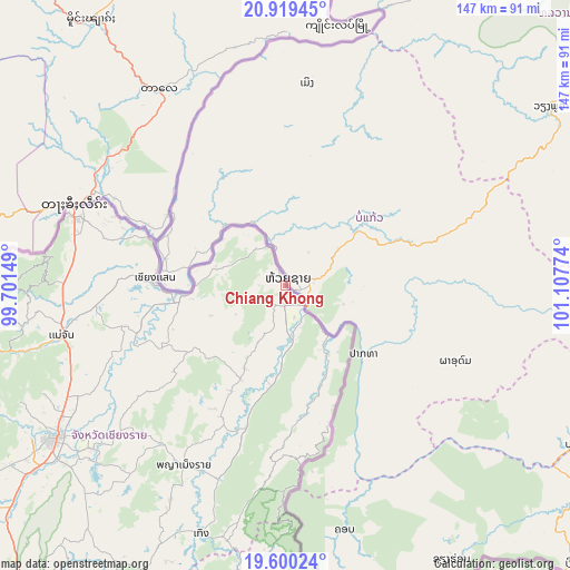
Chiang Khong GPS coordinates[2]
20° 15' 40.5" North, 100° 24' 16.596" East
| Map corner | latitude | longitude |
|---|---|---|
| Upper-left | 20.91945°, | 99.70149° |
| Center: | 20.26125°, | 100.40461° |
| Lower-right: | 19.60024°, | 101.10774° |
| Map W x H: | 146.7×146.7 km | = 91.2×91.2mi |
| max Lat: | 20.43353° ⇑0.3% North |
| Chiang Khong: | 20.26125° |
| min Lat: | ⇓99.7% South 5.77434° |
| min Long | Chiang Khong | max Long |
| 97.93288° | 100.40461° | 105.49506° |
| W 38.4%⇐ | ⇒61.6% E |
Elevation
Elevation of Chiang Khong is 358 m = 1175 ft, and this is 232.5 m = 763 ft above average elevation for this country.
| Max E: |
1011 m = 3317 ft | 6.3% |
| Chiang Khong | 358 m 1175 ft | |
| Avg. | 125.5 m = 412 ft | |
Min E: |
1 m = 3 ft | 93.7% |
See also: Thailand elevation on elevation.city.
Geographical zone
Chiang Khong is located in North Torrid zone (between Equator and Tropic of Cancer). Distance of this Northern Tropic circle is 353.1 km =219.4 mi to North.| Distance of | km | miles | from Chiang Khong |
|---|---|---|---|
| North Pole | 7754.2 | 4818.2 | to North |
| Arctic Circle | 5148.3 | 3199 | to North |
| Tropic Cancer | 353.1 | 219.4 | to North |
| Equator | 2252.8 | 1399.8 | to South |


Nearby cities:
15 places around Chiang Khong: (largest is in red/bold)
• Ban Ho Mae Salong
81.2 km =50.5 mi,  262°
262°
• Chiang Kham
82.8 km =51.4 mi,  187°
187°
• Chiang Rai
71.5 km =44.4 mi,  236°
236°
• Chiang Saen
33.2 km =20.6 mi,  272°
272°
• Doi Luang
35.6 km =22.1 mi, 243°
• Khun Tan
49.9 km =31 mi,  197°
197°
• Mae Chan
59 km =36.7 mi, 257°
• Mae Fa Luang
63.2 km =39.3 mi, 270°
• Mae Sai
58.3 km =36.2 mi,  289°
289°
• Phaya Mengrai
52.8 km =32.8 mi,  209°
209°
• Phu Sang
74.1 km =46 mi, 186°
• Thoeng
67.7 km =42.1 mi, 198°
• Wiang Chai
64.7 km =40.2 mi,  229°
229°
• Wiang Chiang Rung
45.6 km =28.3 mi, 232°
• Wiang Kaen
20 km =12.4 mi,  145°
145°
Sources, notices
• [Note1] Compared only with cities in Thailand existing in our database
• [Src1] Map data: © OpenStreetMap contributors (CC-BY-SA)
• [Src2] Other city data from geonames.org with taken over terms of usage.
• [Src3] Geographical zone / Annual Mean Temperature by Robert A. Rohde @ Wikipedia
