Chiang Rai geodata
Chiang Rai is a seat of a first-order administrative division; located in Thailand in Asia/Bangkok (GMT+7) time zone. With population of 78,756 people, there are 29 cities with bigger population in this country. Compared to other cities in Thailand, 98.9% of cities are located further ↓South; 78.3% of cities are located further →East and 95.6% of cities have lower elevation than Chiang Rai. Note1


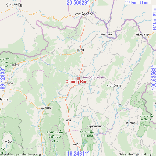
Chiang Rai GPS coordinates[2]
19° 54' 30.888" North, 99° 49' 57" East
| Map corner | latitude | longitude |
|---|---|---|
| Upper-left | 20.56829°, | 99.12938° |
| Center: | 19.90858°, | 99.8325° |
| Lower-right: | 19.24611°, | 100.53563° |
| Map W x H: | 147×147 km | = 91.3×91.3mi |
| max Lat: | 20.43353° ⇑1.1% North |
| Chiang Rai: | 19.90858° |
| min Lat: | ⇓98.9% South 5.77434° |
| min Long | Chiang Rai | max Long |
| 97.93288° | 99.8325° | 105.49506° |
| W 21.7%⇐ | ⇒78.3% E |
Elevation
Elevation of Chiang Rai is 401 m = 1316 ft, and this is 275.5 m = 904 ft above average elevation for this country.
| Max E: |
1011 m = 3317 ft | 4.4% |
| Chiang Rai | 401 m 1316 ft | |
| Avg. | 125.5 m = 412 ft | |
Min E: |
1 m = 3 ft | 95.6% |
See also: Chiang Rai elevation on elevation.city.
Geographical zone
Chiang Rai is located in North Torrid zone (between Equator and Tropic of Cancer). Distance of this Northern Tropic circle is 392.3 km =243.8 mi to North.| Distance of | km | miles | from Chiang Rai |
|---|---|---|---|
| North Pole | 7793.4 | 4842.6 | to North |
| Arctic Circle | 5187.5 | 3223.4 | to North |
| Tropic Cancer | 392.3 | 243.8 | to North |
| Equator | 2213.6 | 1375.5 | to South |


Nearby cities:
15 places around Chiang Rai: (largest is in red/bold)
• Ban Ho Mae Salong
35.4 km =22 mi,  324°
324°
• Chiang Saen
48.6 km =30.2 mi,  33°
33°
• Doi Luang
36.3 km =22.6 mi,  50°
50°
• Khun Tan
45.3 km =28.1 mi,  100°
100°
• Mae Ai
57.4 km =35.7 mi,  283°
283°
• Mae Chan
26.6 km =16.5 mi,  4°
4°
• Mae Fa Luang
39.9 km =24.8 mi,  354°
354°
• Mae Lao
19.2 km =11.9 mi,  226°
226°
• Mae Suai
41.2 km =25.6 mi, 227°
• Pa Daet
47.9 km =29.8 mi,  159°
159°
• Phan
40.6 km =25.2 mi,  193°
193°
• Phaya Mengrai
34.2 km =21.3 mi, 101°
• Thoeng
45.3 km =28.1 mi,  123°
123°
• Wiang Chai
10.9 km =6.8 mi, 104°
• Wiang Chiang Rung
26.1 km =16.2 mi,  63°
63°
Sources, notices
• [Note1] Compared only with cities in Thailand existing in our database
• [Src1] Map data: © OpenStreetMap contributors (CC-BY-SA)
• [Src2] Other city data from geonames.org with taken over terms of usage.
• [Src3] Geographical zone / Annual Mean Temperature by Robert A. Rohde @ Wikipedia
