Chiang Kham geodata
Chiang Kham (Phayao) is a seat of a second-order administrative division; located in Thailand in Asia/Bangkok (GMT+7) time zone. With population of 14,092 people, there are 234 cities with bigger population in this country. Compared to other cities in Thailand, 97.6% of cities are located further ↓South; 65.2% of cities are located further →East and 95.3% of cities have lower elevation than Chiang Kham. Note1


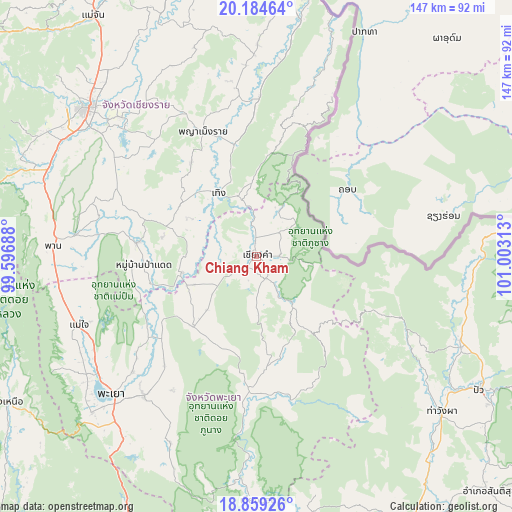
Chiang Kham GPS coordinates[2]
19° 31' 23.916" North, 100° 18' 0" East
| Map corner | latitude | longitude |
|---|---|---|
| Upper-left | 20.18464°, | 99.59688° |
| Center: | 19.52331°, | 100.3° |
| Lower-right: | 18.85926°, | 101.00313° |
| Map W x H: | 147.4×147.4 km | = 91.6×91.6mi |
| max Lat: | 20.43353° ⇑2.4% North |
| Chiang Kham: | 19.52331° |
| min Lat: | ⇓97.6% South 5.77434° |
| min Long | Chiang Kham | max Long |
| 97.93288° | 100.3° | 105.49506° |
| W 34.8%⇐ | ⇒65.2% E |
Elevation
Elevation of Chiang Kham is 396 m = 1299 ft, and this is 270.5 m = 887 ft above average elevation for this country.
| Max E: |
1011 m = 3317 ft | 4.7% |
| Chiang Kham | 396 m 1299 ft | |
| Avg. | 125.5 m = 412 ft | |
Min E: |
1 m = 3 ft | 95.3% |
See also: Thailand elevation on elevation.city.
Geographical zone
Chiang Kham is located in North Torrid zone (between Equator and Tropic of Cancer). Distance of this Northern Tropic circle is 435.1 km =270.4 mi to North.| Distance of | km | miles | from Chiang Kham |
|---|---|---|---|
| North Pole | 7836.3 | 4869.2 | to North |
| Arctic Circle | 5230.4 | 3250 | to North |
| Tropic Cancer | 435.1 | 270.4 | to North |
| Equator | 2170.8 | 1348.9 | to South |


Nearby cities:
15 places around Chiang Kham: (largest is in red/bold)
• Chun
27 km =16.8 mi,  219°
219°
• Dok Kham Tai
51.4 km =31.9 mi, 218°
• Khun Tan
34.8 km =21.6 mi,  352°
352°
• Mae Chai
54.6 km =33.9 mi,  248°
248°
• Pa Daet
32.3 km =20.1 mi,  266°
266°
• Phan
58.7 km =36.5 mi, 273°
• Phaya Mengrai
39.3 km =24.4 mi,  337°
337°
• Phayao
57.5 km =35.7 mi,  230°
230°
• Phu Kam Yao
44.6 km =27.7 mi, 230°
• Phu Sang
8.8 km =5.5 mi,  16°
16°
• Pong
41.7 km =25.9 mi,  183°
183°
• Song Khwae
45.8 km =28.5 mi,  113°
113°
• Thoeng
21.1 km =13.1 mi,  328°
328°
• Wiang Chai
55.5 km =34.5 mi,  316°
316°
• Wiang Chiang Rung
60.1 km =37.3 mi, 334°
Sources, notices
• [Note1] Compared only with cities in Thailand existing in our database
• [Src1] Map data: © OpenStreetMap contributors (CC-BY-SA)
• [Src2] Other city data from geonames.org with taken over terms of usage.
• [Src3] Geographical zone / Annual Mean Temperature by Robert A. Rohde @ Wikipedia
