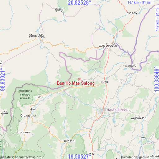
Ban Ho Mae Salong geodata
Ban Ho Mae Salong (Chiang Rai) is a populated place; located in Thailand in Asia/Bangkok (GMT+7) time zone. With population of 540 people, there are 330 cities with bigger population in this country. Compared to other cities in Thailand, 99.6% of cities are located further ↓South; 82.4% of cities are located further →East and 100% of cities have lower elevation than Ban Ho Mae Salong. Note1
Ban Ho Mae Salong GPS coordinates[2]
20° 10' 0.012" North, 99° 37' 59.988" East
| Map corner | latitude | longitude |
|---|---|---|
| Upper-left | 20.82528°, | 98.93021° |
| Center: | 20.16667°, | 99.63333° |
| Lower-right: | 19.50527°, | 100.33646° |
| Map W x H: | 146.8×146.8 km | = 91.2×91.2mi |
| max Lat: | 20.43353° ⇑0.4% North |
| Ban Ho Mae Salong: | 20.16667° |
| min Lat: | ⇓99.6% South 5.77434° |
| min Long | Ban Ho Mae Salo | max Long |
| 97.93288° | 99.63333° | 105.49506° |
| W 17.6%⇐ | ⇒82.4% E |
Elevation
Elevation of Ban Ho Mae Salong is 1011 m = 3317 ft, and this is 885.5 m = 2905 ft above average elevation for this country.
| Max E: |
1011 m = 3317 ft | 0% |
| Ban Ho Mae Salong | 1011 m 3317 ft | |
| Avg. | 125.5 m = 412 ft | |
Min E: |
1 m = 3 ft | 100% |
See also: Thailand elevation on elevation.city.
Geographical zone
Ban Ho Mae Salong is located in North Torrid zone (between Equator and Tropic of Cancer). Distance of this Northern Tropic circle is 363.6 km =225.9 mi to North.| Distance of | km | miles | from Ban Ho Mae Salong |
|---|---|---|---|
| North Pole | 7764.7 | 4824.8 | to North |
| Arctic Circle | 5158.9 | 3205.6 | to North |
| Tropic Cancer | 363.6 | 225.9 | to North |
| Equator | 2242.3 | 1393.3 | to South |


Nearby cities:
15 places around Ban Ho Mae Salong: (largest is in red/bold)
• Chai Prakan
70.7 km =43.9 mi,  226°
226°
• Chiang Rai
35.4 km =22 mi,  144°
144°
• Chiang Saen
48.8 km =30.3 mi,  75°
75°
• Doi Luang
48.9 km =30.4 mi,  96°
96°
• Fang
51.8 km =32.2 mi,  237°
237°
• Mae Ai
38.2 km =23.7 mi,  246°
246°
• Mae Chan
23 km =14.3 mi,  95°
95°
• Mae Fa Luang
20.5 km =12.7 mi,  57°
57°
• Mae Lao
42.4 km =26.3 mi,  170°
170°
• Mae Sai
39 km =24.2 mi,  40°
40°
• Mae Suai
57.5 km =35.7 mi,  189°
189°
• Phan
69 km =42.9 mi,  170°
170°
• Phaya Mengrai
64.8 km =40.3 mi,  122°
122°
• Wiang Chai
44.4 km =27.6 mi,  135°
135°
• Wiang Chiang Rung
47.4 km =29.5 mi,  111°
111°
Sources, notices
• [Note1] Compared only with cities in Thailand existing in our database
• [Src1] Map data: © OpenStreetMap contributors (CC-BY-SA)
• [Src2] Other city data from geonames.org with taken over terms of usage.
• [Src3] Geographical zone / Annual Mean Temperature by Robert A. Rohde @ Wikipedia


