Mae Chan geodata
Mae Chan (Chiang Rai) is a seat of a second-order administrative division; located in Thailand in Asia/Bangkok (GMT+7) time zone. With population of 37,672 people, there are 83 cities with bigger population in this country. Compared to other cities in Thailand, 99.5% of cities are located further ↓South; 77.6% of cities are located further →East and 96.3% of cities have lower elevation than Mae Chan. Note1


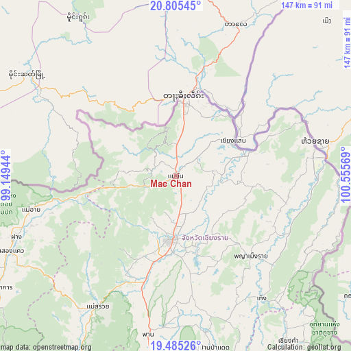
Mae Chan GPS coordinates[2]
20° 8' 48.3" North, 99° 51' 9.216" East
| Map corner | latitude | longitude |
|---|---|---|
| Upper-left | 20.80545°, | 99.14944° |
| Center: | 20.14675°, | 99.85256° |
| Lower-right: | 19.48526°, | 100.55569° |
| Map W x H: | 146.8×146.8 km | = 91.2×91.2mi |
| max Lat: | 20.43353° ⇑0.5% North |
| Mae Chan: | 20.14675° |
| min Lat: | ⇓99.5% South 5.77434° |
| min Long | Mae Chan | max Long |
| 97.93288° | 99.85256° | 105.49506° |
| W 22.4%⇐ | ⇒77.6% E |
Elevation
Elevation of Mae Chan is 416 m = 1365 ft, and this is 290.5 m = 953 ft above average elevation for this country.
| Max E: |
1011 m = 3317 ft | 3.7% |
| Mae Chan | 416 m 1365 ft | |
| Avg. | 125.5 m = 412 ft | |
Min E: |
1 m = 3 ft | 96.3% |
See also: Thailand elevation on elevation.city.
Geographical zone
Mae Chan is located in North Torrid zone (between Equator and Tropic of Cancer). Distance of this Northern Tropic circle is 365.8 km =227.3 mi to North.| Distance of | km | miles | from Mae Chan |
|---|---|---|---|
| North Pole | 7767 | 4826.2 | to North |
| Arctic Circle | 5161.1 | 3207 | to North |
| Tropic Cancer | 365.8 | 227.3 | to North |
| Equator | 2240.1 | 1391.9 | to South |


Nearby cities:
15 places around Mae Chan: (largest is in red/bold)
• Ban Ho Mae Salong
23 km =14.3 mi,  275°
275°
• Chiang Khong
59 km =36.7 mi,  77°
77°
• Chiang Rai
26.6 km =16.5 mi,  184°
184°
• Chiang Saen
28.3 km =17.6 mi,  59°
59°
• Doi Luang
25.9 km =16.1 mi,  97°
97°
• Khun Tan
54.9 km =34.1 mi,  129°
129°
• Mae Ai
59.3 km =36.8 mi,  257°
257°
• Mae Fa Luang
14.4 km =8.9 mi,  336°
336°
• Mae Lao
42.8 km =26.6 mi,  201°
201°
• Mae Sai
32 km =19.9 mi,  4°
4°
• Mae Suai
63.4 km =39.4 mi,  210°
210°
• Phaya Mengrai
45.6 km =28.3 mi,  136°
136°
• Thoeng
62.6 km =38.9 mi,  145°
145°
• Wiang Chai
30.4 km =18.9 mi,  163°
163°
• Wiang Chiang Rung
25.9 km =16.1 mi,  124°
124°
Sources, notices
• [Note1] Compared only with cities in Thailand existing in our database
• [Src1] Map data: © OpenStreetMap contributors (CC-BY-SA)
• [Src2] Other city data from geonames.org with taken over terms of usage.
• [Src3] Geographical zone / Annual Mean Temperature by Robert A. Rohde @ Wikipedia
