Bo Kluea geodata
Bo Kluea (Nan) is a seat of a second-order administrative division; located in Thailand in Asia/Bangkok (GMT+7) time zone. In our database, there are 331 cities with bigger population. Compared to other cities in Thailand, 95.7% of cities are located further ↓South; 56.8% of cities are located further ←West and 99.1% of cities have lower elevation than Bo Kluea. Note1


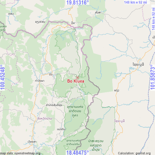
Bo Kluea GPS coordinates[2]
19° 9' 1.044" North, 101° 9' 20.16" East
| Map corner | latitude | longitude |
|---|---|---|
| Upper-left | 19.81316°, | 100.45248° |
| Center: | 19.15029°, | 101.1556° |
| Lower-right: | 18.48475°, | 101.85873° |
| Map W x H: | 147.7×147.7 km | = 91.8×91.8mi |
| max Lat: | 20.43353° ⇑4.3% North |
| Bo Kluea: | 19.15029° |
| min Lat: | ⇓95.7% South 5.77434° |
| min Long | Bo Kluea | max Long |
| 97.93288° | 101.1556° | 105.49506° |
| W 56.8%⇐ | ⇒43.2% E |
Elevation
Elevation of Bo Kluea is 674 m = 2211 ft, and this is 548.5 m = 1800 ft above average elevation for this country.
| Max E: |
1011 m = 3317 ft | 0.90000000000001% |
| Bo Kluea | 674 m 2211 ft | |
| Avg. | 125.5 m = 412 ft | |
Min E: |
1 m = 3 ft | 99.1% |
See also: Thailand elevation on elevation.city.
Geographical zone
Bo Kluea is located in North Torrid zone (between Equator and Tropic of Cancer). Distance of this Northern Tropic circle is 476.6 km =296.1 mi to North.| Distance of | km | miles | from Bo Kluea |
|---|---|---|---|
| North Pole | 7877.7 | 4895 | to North |
| Arctic Circle | 5271.9 | 3275.8 | to North |
| Tropic Cancer | 476.6 | 296.1 | to North |
| Equator | 2129.3 | 1323.1 | to South |


Nearby cities:
15 places around Bo Kluea: (largest is in red/bold)
• Ban Luang
82.6 km =51.3 mi,  246°
246°
• Chaloem Phra Kiat
48.3 km =30 mi,  350°
350°
• Chiang Kham
98.9 km =61.5 mi,  294°
294°
• Chiang Klang
34.7 km =21.6 mi,  297°
297°
• Chiang Muan
93.9 km =58.3 mi, 252°
• Mae Charim
51.8 km =32.2 mi,  197°
197°
• Nan
56.8 km =35.3 mi,  224°
224°
• Phu Phiang
58.8 km =36.5 mi, 219°
• Pong
92.5 km =57.5 mi,  269°
269°
• Pua
25.3 km =15.7 mi,  276°
276°
• Santi Suk
34.6 km =21.5 mi, 220°
• Song Khwae
53.1 km =33 mi, 295°
• Tha Wang Pha
36.3 km =22.6 mi, 265°
• Thung Chang
39.5 km =24.5 mi,  312°
312°
• Wiang Sa
75.3 km =46.8 mi, 215°
Sources, notices
• [Note1] Compared only with cities in Thailand existing in our database
• [Src1] Map data: © OpenStreetMap contributors (CC-BY-SA)
• [Src2] Other city data from geonames.org with taken over terms of usage.
• [Src3] Geographical zone / Annual Mean Temperature by Robert A. Rohde @ Wikipedia
