Chiang Muan geodata
Chiang Muan (Phayao) is a seat of a second-order administrative division; located in Thailand in Asia/Bangkok (GMT+7) time zone. In our database, there are 331 cities with bigger population. Compared to other cities in Thailand, 95% of cities are located further ↓South; 64.8% of cities are located further →East and 89.8% of cities have lower elevation than Chiang Muan. Note1


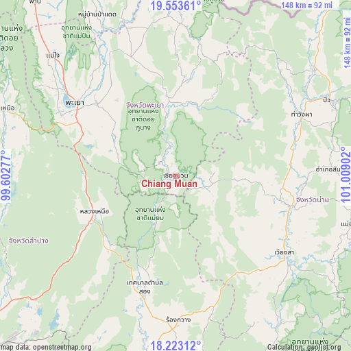
Chiang Muan GPS coordinates[2]
18° 53' 22.884" North, 100° 18' 21.204" East
| Map corner | latitude | longitude |
|---|---|---|
| Upper-left | 19.55361°, | 99.60277° |
| Center: | 18.88969°, | 100.30589° |
| Lower-right: | 18.22312°, | 101.00902° |
| Map W x H: | 147.9×147.9 km | = 91.9×91.9mi |
| max Lat: | 20.43353° ⇑5% North |
| Chiang Muan: | 18.88969° |
| min Lat: | ⇓95% South 5.77434° |
| min Long | Chiang Muan | max Long |
| 97.93288° | 100.30589° | 105.49506° |
| W 35.2%⇐ | ⇒64.8% E |
Elevation
Elevation of Chiang Muan is 275 m = 902 ft, and this is 149.5 m = 490 ft above average elevation for this country.
| Max E: |
1011 m = 3317 ft | 10.2% |
| Chiang Muan | 275 m 902 ft | |
| Avg. | 125.5 m = 412 ft | |
Min E: |
1 m = 3 ft | 89.8% |
See also: Thailand elevation on elevation.city.
Geographical zone
Chiang Muan is located in North Torrid zone (between Equator and Tropic of Cancer). Distance of this Northern Tropic circle is 505.6 km =314.2 mi to North.| Distance of | km | miles | from Chiang Muan |
|---|---|---|---|
| North Pole | 7906.7 | 4913 | to North |
| Arctic Circle | 5300.8 | 3293.8 | to North |
| Tropic Cancer | 505.6 | 314.2 | to North |
| Equator | 2100.3 | 1305.1 | to South |


Nearby cities:
15 places around Chiang Muan: (largest is in red/bold)
• Ban Luang
14.5 km =9 mi,  107°
107°
• Chun
52.9 km =32.9 mi,  340°
340°
• Dok Kham Tai
44.7 km =27.8 mi,  312°
312°
• Nan
51.2 km =31.8 mi,  103°
103°
• Ngao
37.5 km =23.3 mi,  246°
246°
• Phayao
56.1 km =34.9 mi, 306°
• Phu Kam Yao
55.1 km =34.2 mi,  320°
320°
• Phu Phiang
54.5 km =33.9 mi, 107°
• Pong
29 km =18 mi,  353°
353°
• Rong Kwang
61.2 km =38 mi,  178°
178°
• Santi Suk
66.9 km =41.6 mi,  87°
87°
• Song
48.2 km =30 mi,  195°
195°
• Song Khwae
66.7 km =41.4 mi,  38°
38°
• Tha Wang Pha
59.1 km =36.7 mi,  64°
64°
• Wiang Sa
56.1 km =34.9 mi,  125°
125°
Sources, notices
• [Note1] Compared only with cities in Thailand existing in our database
• [Src1] Map data: © OpenStreetMap contributors (CC-BY-SA)
• [Src2] Other city data from geonames.org with taken over terms of usage.
• [Src3] Geographical zone / Annual Mean Temperature by Robert A. Rohde @ Wikipedia
