Pong geodata
Pong (Phayao) is a seat of a second-order administrative division; located in Thailand in Asia/Bangkok (GMT+7) time zone. With population of 14,392 people, there are 227 cities with bigger population in this country. Compared to other cities in Thailand, 95.6% of cities are located further ↓South; 65.3% of cities are located further →East and 91.5% of cities have lower elevation than Pong. Note1


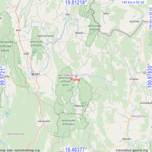
Pong GPS coordinates[2]
19° 8' 57.516" North, 100° 16' 30.792" East
| Map corner | latitude | longitude |
|---|---|---|
| Upper-left | 19.81218°, | 99.5721° |
| Center: | 19.14931°, | 100.27522° |
| Lower-right: | 18.48377°, | 100.97835° |
| Map W x H: | 147.7×147.7 km | = 91.8×91.8mi |
| max Lat: | 20.43353° ⇑4.4% North |
| Pong: | 19.14931° |
| min Lat: | ⇓95.6% South 5.77434° |
| min Long | Pong | max Long |
| 97.93288° | 100.27522° | 105.49506° |
| W 34.7%⇐ | ⇒65.3% E |
Elevation
Elevation of Pong is 300 m = 984 ft, and this is 174.5 m = 573 ft above average elevation for this country.
| Max E: |
1011 m = 3317 ft | 8.5% |
| Pong | 300 m 984 ft | |
| Avg. | 125.5 m = 412 ft | |
Min E: |
1 m = 3 ft | 91.5% |
See also: Thailand elevation on elevation.city.
Geographical zone
Pong is located in North Torrid zone (between Equator and Tropic of Cancer). Distance of this Northern Tropic circle is 476.7 km =296.2 mi to North.| Distance of | km | miles | from Pong |
|---|---|---|---|
| North Pole | 7877.9 | 4895.1 | to North |
| Arctic Circle | 5272 | 3275.9 | to North |
| Tropic Cancer | 476.7 | 296.2 | to North |
| Equator | 2129.2 | 1323 | to South |


Nearby cities:
15 places around Pong: (largest is in red/bold)
• Ban Luang
37.4 km =23.2 mi,  152°
152°
• Chiang Kham
41.7 km =25.9 mi,  3°
3°
• Chiang Klang
63.6 km =39.5 mi,  75°
75°
• Chiang Muan
29 km =18 mi,  173°
173°
• Chun
25.5 km =15.8 mi,  324°
324°
• Dok Kham Tai
29.6 km =18.4 mi,  272°
272°
• Mae Chai
53.1 km =33 mi,  294°
294°
• Ngao
53.7 km =33.4 mi,  215°
215°
• Pa Daet
49.4 km =30.7 mi, 323°
• Phayao
41.9 km =26 mi,  276°
276°
• Phu Kam Yao
34.8 km =21.6 mi, 292°
• Phu Sang
50.3 km =31.3 mi,  5°
5°
• Song Khwae
50.4 km =31.3 mi,  62°
62°
• Tha Wang Pha
56.4 km =35 mi,  93°
93°
• Thoeng
60.2 km =37.4 mi,  351°
351°
Sources, notices
• [Note1] Compared only with cities in Thailand existing in our database
• [Src1] Map data: © OpenStreetMap contributors (CC-BY-SA)
• [Src2] Other city data from geonames.org with taken over terms of usage.
• [Src3] Geographical zone / Annual Mean Temperature by Robert A. Rohde @ Wikipedia
