Ban Phraek geodata
Ban Phraek (Phra Nakhon Si Ayutthaya) is a seat of a second-order administrative division; located in Thailand in Asia/Bangkok (GMT+7) time zone. In our database, there are 331 cities with bigger population. Compared to other cities in Thailand, 56.3% of cities are located further ↑North; 54.8% of cities are located further →East and 94.4% of cities have higher elevation than Ban Phraek. Note1


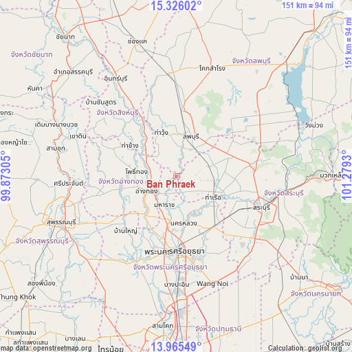
Ban Phraek GPS coordinates[2]
14° 38' 48.516" North, 100° 34' 34.212" East
| Map corner | latitude | longitude |
|---|---|---|
| Upper-left | 15.32602°, | 99.87305° |
| Center: | 14.64681°, | 100.57617° |
| Lower-right: | 13.96549°, | 101.2793° |
| Map W x H: | 151.3×151.3 km | = 94×94mi |
| max Lat: | 20.43353° ⇑56.3% North |
| Ban Phraek: | 14.64681° |
| min Lat: | ⇓43.7% South 5.77434° |
| min Long | Ban Phraek | max Long |
| 97.93288° | 100.57617° | 105.49506° |
| W 45.2%⇐ | ⇒54.8% E |
Elevation
Elevation of Ban Phraek is 7 m = 23 ft, and this is 118.5 m = 389 ft below average elevation for this country.
| Max E: |
1011 m = 3317 ft | 94.4% |
| Avg. | 125.5 m = 412 ft | |
| Ban Phraek | 7 m = 23 ft | |
Min E: |
1 m = 3 ft | 5.6% |
See also: Thailand elevation on elevation.city.
Geographical zone
Ban Phraek is located in North Torrid zone (between Equator and Tropic of Cancer). Distance of this Northern Tropic circle is 977.3 km =607.3 mi to North.| Distance of | km | miles | from Ban Phraek |
|---|---|---|---|
| North Pole | 8378.5 | 5206.2 | to North |
| Arctic Circle | 5772.6 | 3586.9 | to North |
| Tropic Cancer | 977.3 | 607.3 | to North |
| Equator | 1628.6 | 1012 | to South |


Nearby cities:
15 places around Ban Phraek: (largest is in red/bold)
• Ang Thong
14.8 km =9.2 mi,  243°
243°
• Ban Mo
16.6 km =10.3 mi,  102°
102°
• Ban Thai Tan
10 km =6.2 mi,  253°
253°
• Bang Pahan
20.8 km =12.9 mi,  189°
189°
• Chaiyo
10.5 km =6.5 mi,  271°
271°
• Chaiyo
12 km =7.5 mi,  285°
285°
• Don Phut
8.3 km =5.2 mi,  137°
137°
• Lop Buri
18.8 km =11.7 mi,  26°
26°
• Maha Rat
13.7 km =8.5 mi,  202°
202°
• Nakhon Luang
20.7 km =12.9 mi,  170°
170°
• Nong Don
14.9 km =9.3 mi,  73°
73°
• Pho Thong
18.2 km =11.3 mi,  277°
277°
• Phrom Buri
20.8 km =12.9 mi,  320°
320°
• Tha Ruea
18.4 km =11.4 mi,  118°
118°
• Tha Wung
19.9 km =12.4 mi,  336°
336°
Sources, notices
• [Note1] Compared only with cities in Thailand existing in our database
• [Src1] Map data: © OpenStreetMap contributors (CC-BY-SA)
• [Src2] Other city data from geonames.org with taken over terms of usage.
• [Src3] Geographical zone / Annual Mean Temperature by Robert A. Rohde @ Wikipedia
