Sukhothai geodata
Sukhothai is a seat of a first-order administrative division; located in Thailand in Asia/Bangkok (GMT+7) time zone. With population of 37,000 people, there are 85 cities with bigger population in this country. Compared to other cities in Thailand, 78.6% of cities are located further ↓South; 78.7% of cities are located further →East and 56.6% of cities have higher elevation than Sukhothai. Note1


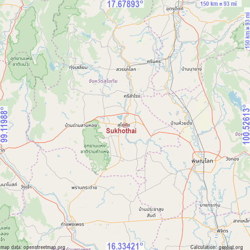
Sukhothai GPS coordinates[2]
17° 0' 28.008" North, 99° 49' 22.8" East
| Map corner | latitude | longitude |
|---|---|---|
| Upper-left | 17.67893°, | 99.11988° |
| Center: | 17.00778°, | 99.823° |
| Lower-right: | 16.33421°, | 100.52613° |
| Map W x H: | 149.5×149.5 km | = 92.9×92.9mi |
| max Lat: | 20.43353° ⇑21.4% North |
| Sukhothai: | 17.00778° |
| min Lat: | ⇓78.6% South 5.77434° |
| min Long | Sukhothai | max Long |
| 97.93288° | 99.823° | 105.49506° |
| W 21.3%⇐ | ⇒78.7% E |
Elevation
Elevation of Sukhothai is 53 m = 174 ft, and this is 72.5 m = 238 ft below average elevation for this country.
| Max E: |
1011 m = 3317 ft | 56.6% |
| Avg. | 125.5 m = 412 ft | |
| Sukhothai | 53 m = 174 ft | |
Min E: |
1 m = 3 ft | 43.4% |
See also: Thailand elevation on elevation.city.
Geographical zone
Sukhothai is located in North Torrid zone (between Equator and Tropic of Cancer). Distance of this Northern Tropic circle is 714.8 km =444.2 mi to North.| Distance of | km | miles | from Sukhothai |
|---|---|---|---|
| North Pole | 8116 | 5043 | to North |
| Arctic Circle | 5510.1 | 3423.8 | to North |
| Tropic Cancer | 714.8 | 444.2 | to North |
| Equator | 1891.1 | 1175.1 | to South |


Nearby cities:
15 places around Sukhothai: (largest is in red/bold)
• Ban Dan Lan Hoi
26.4 km =16.4 mi,  269°
269°
• Ban Na
9.6 km =6 mi,  276°
276°
• Bang Rakam
41.8 km =26 mi,  131°
131°
• Khiri Mat
19.6 km =12.2 mi,  187°
187°
• Kong Krailat
17.6 km =10.9 mi,  110°
110°
• Lan Krabue
45.4 km =28.2 mi,  176°
176°
• Phichai
41.9 km =26 mi,  41°
41°
• Phitsanulok
50.6 km =31.4 mi, 113°
• Phran Kratai
45.5 km =28.3 mi,  213°
213°
• Phrom Phiram
40.4 km =25.1 mi,  85°
85°
• Sawankhalok
34.3 km =21.3 mi,  1°
1°
• Si Nakhon
41.7 km =25.9 mi,  24°
24°
• Si Samrong
17.9 km =11.1 mi,  13°
13°
• Thung Saliam
44.6 km =27.7 mi,  321°
321°
• Wat Bot
54.2 km =33.7 mi, 93°
Sources, notices
• [Note1] Compared only with cities in Thailand existing in our database
• [Src1] Map data: © OpenStreetMap contributors (CC-BY-SA)
• [Src2] Other city data from geonames.org with taken over terms of usage.
• [Src3] Geographical zone / Annual Mean Temperature by Robert A. Rohde @ Wikipedia
