Ban Na geodata
Ban Na (Sukhothai) is a populated place; located in Thailand in Asia/Bangkok (GMT+7) time zone. With population of 40,174 people, there are 77 cities with bigger population in this country. Compared to other cities in Thailand, 78.7% of cities are located further ↓South; 80.5% of cities are located further →East and 55% of cities have higher elevation than Ban Na. Note1


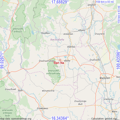
Ban Na GPS coordinates[2]
17° 1' 1.812" North, 99° 43' 58.188" East
| Map corner | latitude | longitude |
|---|---|---|
| Upper-left | 17.68829°, | 99.02971° |
| Center: | 17.01717°, | 99.73283° |
| Lower-right: | 16.34364°, | 100.43596° |
| Map W x H: | 149.5×149.5 km | = 92.9×92.9mi |
| max Lat: | 20.43353° ⇑21.3% North |
| Ban Na: | 17.01717° |
| min Lat: | ⇓78.7% South 5.77434° |
| min Long | Ban Na | max Long |
| 97.93288° | 99.73283° | 105.49506° |
| W 19.5%⇐ | ⇒80.5% E |
Elevation
Elevation of Ban Na is 59 m = 194 ft, and this is 66.5 m = 218 ft below average elevation for this country.
| Max E: |
1011 m = 3317 ft | 55% |
| Avg. | 125.5 m = 412 ft | |
| Ban Na | 59 m = 194 ft | |
Min E: |
1 m = 3 ft | 45% |
See also: Ban Na elevation on elevation.city.
Geographical zone
Ban Na is located in North Torrid zone (between Equator and Tropic of Cancer). Distance of this Northern Tropic circle is 713.8 km =443.5 mi to North.| Distance of | km | miles | from Ban Na |
|---|---|---|---|
| North Pole | 8114.9 | 5042.4 | to North |
| Arctic Circle | 5509 | 3423.1 | to North |
| Tropic Cancer | 713.8 | 443.5 | to North |
| Equator | 1892.1 | 1175.7 | to South |


Nearby cities:
15 places around Ban Na: (largest is in red/bold)
• Ban Dan Lan Hoi
16.8 km =10.4 mi,  266°
266°
• Bang Rakam
50 km =31.1 mi,  125°
125°
• Khiri Mat
21.7 km =13.5 mi,  160°
160°
• Kong Krailat
27 km =16.8 mi,  105°
105°
• Kosamphi Nakhon
59.2 km =36.8 mi,  223°
223°
• Lan Krabue
48 km =29.8 mi,  165°
165°
• Phichai
48.1 km =29.9 mi,  51°
51°
• Phran Kratai
42 km =26.1 mi,  201°
201°
• Phrom Phiram
49.9 km =31 mi,  87°
87°
• Sawankhalok
34.8 km =21.6 mi,  17°
17°
• Si Nakhon
45.6 km =28.3 mi,  36°
36°
• Si Samrong
21.3 km =13.2 mi, 40°
• Si Satchanalai
55.6 km =34.5 mi,  2°
2°
• Sukhothai
9.6 km =6 mi,  96°
96°
• Thung Saliam
38.4 km =23.9 mi,  331°
331°
Sources, notices
• [Note1] Compared only with cities in Thailand existing in our database
• [Src1] Map data: © OpenStreetMap contributors (CC-BY-SA)
• [Src2] Other city data from geonames.org with taken over terms of usage.
• [Src3] Geographical zone / Annual Mean Temperature by Robert A. Rohde @ Wikipedia
