Obikiik geodata
Obikiik (Khatlon) is a seat of a second-order administrative division; located in Tajikistan in Asia/Dushanbe (GMT+5) time zone. In our database, there are 65 cities with bigger population. Compared to other cities in Tajikistan, 63.6% of cities are located further ↑North; 81.8% of cities are located further →East and 56.8% of cities have higher elevation than Obikiik. Note1


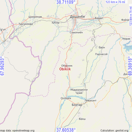
Obikiik GPS coordinates[2]
38° 9' 37.188" North, 68° 39' 57.78" East
| Map corner | latitude | longitude |
|---|---|---|
| Upper-left | 38.71109°, | 67.96293° |
| Center: | 38.16033°, | 68.66605° |
| Lower-right: | 37.60538°, | 69.36918° |
| Map W x H: | 122.9×122.9 km | = 76.4×76.4mi |
| max Lat: | 40.99827° ⇑63.6% North |
| Obikiik: | 38.16033° |
| min Lat: | ⇓36.4% South 36.72484° |
| min Long | Obikiik | max Long |
| 67.60931° | 68.66605° | 73.96674° |
| W 18.2%⇐ | ⇒81.8% E |
Elevation
Elevation of Obikiik is 662 m = 2172 ft, and this is 300.5 m = 986 ft below average elevation for this country.
| Max E: |
3607 m = 11834 ft | 56.8% |
| Avg. | 962.5 m = 3158 ft | |
| Obikiik | 662 m = 2172 ft | |
Min E: |
324 m = 1063 ft | 43.2% |
See also: Tajikistan elevation on elevation.city.
Geographical zone
Obikiik is located in North temperate zone (between Tropic of Cancer and the Arctic Circle). Distance of this Northern Tropic circle is 1637.1 km =1017.2 mi to South.| Distance of | km | miles | from Obikiik |
|---|---|---|---|
| North Pole | 5764 | 3581.6 | to North |
| Arctic Circle | 3158.1 | 1962.4 | to North |
| Tropic Cancer | 1637.1 | 1017.2 | to South |
| Equator | 4243 | 2636.5 | to South |


Nearby cities:
15 places around Obikiik: (largest is in red/bold)
• Abdurahmoni Jomí
26.9 km =16.7 mi,  152°
152°
• Boshkengash
36.1 km =22.4 mi,  19°
19°
• Bŭstonqal’a
37.6 km =23.4 mi,  157°
157°
• Dushanbe
42.9 km =26.7 mi,  13°
13°
• Hisor
41.8 km =26 mi,  346°
346°
• Ismoili Somoní
45.4 km =28.2 mi, 164°
• Kirov
41.5 km =25.8 mi, 155°
• Qŭrghonteppa
37.7 km =23.4 mi, 164°
• Sarband
39.2 km =24.4 mi, 145°
• Shahrinav
54 km =33.6 mi,  327°
327°
• Somoniyon
32.7 km =20.3 mi, 16°
• Tursunzoda
54.5 km =33.9 mi,  315°
315°
• Vahdat
53.4 km =33.2 mi,  34°
34°
• Vakhsh
51.7 km =32.1 mi, 163°
• Yovon
36.7 km =22.8 mi,  62°
62°
Sources, notices
• [Note1] Compared only with cities in Tajikistan existing in our database
• [Src1] Map data: © OpenStreetMap contributors (CC-BY-SA)
• [Src2] Other city data from geonames.org with taken over terms of usage.
• [Src3] Geographical zone / Annual Mean Temperature by Robert A. Rohde @ Wikipedia
