Danghara geodata
Danghara (Khatlon) is a seat of a second-order administrative division; located in Tajikistan in Asia/Dushanbe (GMT+5) time zone. With population of 22,824 people, there are 14 cities with bigger population in this country. Compared to other cities in Tajikistan, 65.9% of cities are located further ↑North; 52.3% of cities are located further →East and 60.2% of cities have higher elevation than Danghara. Note1


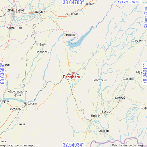
Danghara GPS coordinates[2]
38° 5' 44.808" North, 69° 20' 23.928" East
| Map corner | latitude | longitude |
|---|---|---|
| Upper-left | 38.64703°, | 68.63686° |
| Center: | 38.09578°, | 69.33998° |
| Lower-right: | 37.54034°, | 70.04311° |
| Map W x H: | 123.1×123.1 km | = 76.5×76.5mi |
| max Lat: | 40.99827° ⇑65.9% North |
| Danghara: | 38.09578° |
| min Lat: | ⇓34.1% South 36.72484° |
| min Long | Danghara | max Long |
| 67.60931° | 69.33998° | 73.96674° |
| W 47.7%⇐ | ⇒52.3% E |
Elevation
Elevation of Danghara is 652 m = 2139 ft, and this is 310.5 m = 1019 ft below average elevation for this country.
| Max E: |
3607 m = 11834 ft | 60.2% |
| Avg. | 962.5 m = 3158 ft | |
| Danghara | 652 m = 2139 ft | |
Min E: |
324 m = 1063 ft | 39.8% |
See also: Tajikistan elevation on elevation.city.
Geographical zone
Danghara is located in North temperate zone (between Tropic of Cancer and the Arctic Circle). Distance of this Northern Tropic circle is 1629.9 km =1012.8 mi to South.| Distance of | km | miles | from Danghara |
|---|---|---|---|
| North Pole | 5771.2 | 3586.1 | to North |
| Arctic Circle | 3165.3 | 1966.8 | to North |
| Tropic Cancer | 1629.9 | 1012.8 | to South |
| Equator | 4235.9 | 2632.1 | to South |


Nearby cities:
15 places around Danghara: (largest is in red/bold)
• Abdurahmoni Jomí
49.4 km =30.7 mi,  250°
250°
• Baljuvon
37.7 km =23.4 mi,  51°
51°
• Bŭstonqal’a
52.4 km =32.6 mi,  238°
238°
• Fayzobod
50.2 km =31.2 mi,  357°
357°
• Kirov
52.2 km =32.4 mi,  233°
233°
• Kŭlob
43.9 km =27.3 mi,  117°
117°
• Moskva
54.6 km =33.9 mi,  152°
152°
• Norak
32.7 km =20.3 mi, 357°
• Obikiik
59.4 km =36.9 mi,  276°
276°
• Qŭrghonteppa
56.9 km =35.4 mi, 239°
• Sarband
44.3 km =27.5 mi, 235°
• Sovet
22.4 km =13.9 mi,  104°
104°
• Vahdat
58.6 km =36.4 mi,  330°
330°
• Vose’
42 km =26.1 mi,  140°
140°
• Yovon
35.9 km =22.3 mi,  312°
312°
Sources, notices
• [Note1] Compared only with cities in Tajikistan existing in our database
• [Src1] Map data: © OpenStreetMap contributors (CC-BY-SA)
• [Src2] Other city data from geonames.org with taken over terms of usage.
• [Src3] Geographical zone / Annual Mean Temperature by Robert A. Rohde @ Wikipedia
