Chorbane geodata
Chorbane (Al Mahdīyah) is a populated place; located in Tunisia in Africa/Tunis (GMT+1) time zone. With population of 6,430 people, there are 108 cities with bigger population in this country. Compared to other cities in Tunisia, 72.7% of cities are located further ↑North; 58.7% of cities are located further ←West and 67.1% of cities have lower elevation than Chorbane. Note1


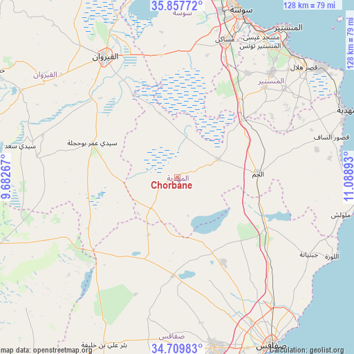
Chorbane GPS coordinates[2]
35° 17' 8.916" North, 10° 23' 8.88" East
| Map corner | latitude | longitude |
|---|---|---|
| Upper-left | 35.85772°, | 9.68267° |
| Center: | 35.28581°, | 10.3858° |
| Lower-right: | 34.70983°, | 11.08893° |
| Map W x H: | 127.6×127.6 km | = 79.3×79.3mi |
| max Lat: | 37.27442° ⇑72.7% North |
| Chorbane: | 35.28581° |
| min Lat: | ⇓27.3% South 32.31662° |
| min Long | Chorbane | max Long |
| 7.87765° | 10.3858° | 11.21965° |
| W 58.7%⇐ | ⇒41.3% E |
Elevation
Elevation of Chorbane is 110 m = 361 ft, and this is 39.4 m = 129 ft below average elevation for this country.
| Max E: |
999 m = 3278 ft | 32.9% |
| Avg. | 149.4 m = 490 ft | |
| Chorbane | 110 m = 361 ft | |
Min E: |
-6 m = -20 ft | 67.1% |
See also: Tunisia elevation on elevation.city.
Geographical zone
Chorbane is located in North temperate zone (between Tropic of Cancer and the Arctic Circle). Distance of this Northern Tropic circle is 1317.5 km =818.7 mi to South.| Distance of | km | miles | from Chorbane |
|---|---|---|---|
| North Pole | 6083.6 | 3780.2 | to North |
| Arctic Circle | 3477.8 | 2161 | to North |
| Tropic Cancer | 1317.5 | 818.7 | to South |
| Equator | 3923.4 | 2437.9 | to South |


Nearby cities:
15 places around Chorbane: (largest is in red/bold)
• Banbalah
59.4 km =36.9 mi,  39°
39°
• Beni Hassane
49.5 km =30.8 mi,  50°
50°
• Djebeniana
55.1 km =34.2 mi,  120°
120°
• Djemmal
50.3 km =31.3 mi, 41°
• El Jem
30.1 km =18.7 mi,  86°
86°
• Kairouan
50.9 km =31.6 mi,  328°
328°
• Ksour Essaf
57.1 km =35.5 mi,  75°
75°
• Menzel Kamel
45.5 km =28.3 mi,  34°
34°
• Mesdour
53.8 km =33.4 mi, 35°
• Msaken
52.4 km =32.6 mi,  19°
19°
• Ouardenine
53.8 km =33.4 mi, 28°
• Sidi Alouane
51.2 km =31.8 mi, 78°
• Sidi Ben Nour
55.4 km =34.4 mi,  60°
60°
• Sidi el Hani
43.3 km =26.9 mi,  351°
351°
• Touza
55.8 km =34.7 mi, 45°
Sources, notices
• [Note1] Compared only with cities in Tunisia existing in our database
• [Src1] Map data: © OpenStreetMap contributors (CC-BY-SA)
• [Src2] Other city data from geonames.org with taken over terms of usage.
• [Src3] Geographical zone / Annual Mean Temperature by Robert A. Rohde @ Wikipedia
