Kairouan geodata
Kairouan is a seat of a first-order administrative division; located in Tunisia in Africa/Tunis (GMT+1) time zone. With population of 119,794 people, there are 3 cities with bigger population in this country. Compared to other cities in Tunisia, 58% of cities are located further ↑North; 54.5% of cities are located further →East and 60.8% of cities have lower elevation than Kairouan. Note1


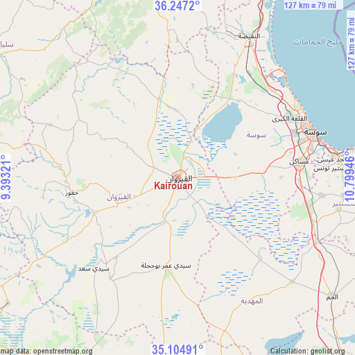
Kairouan GPS coordinates[2]
35° 40' 41.16" North, 10° 5' 46.788" East
| Map corner | latitude | longitude |
|---|---|---|
| Upper-left | 36.2472°, | 9.39321° |
| Center: | 35.6781°, | 10.09633° |
| Lower-right: | 35.10491°, | 10.79946° |
| Map W x H: | 127×127 km | = 78.9×78.9mi |
| max Lat: | 37.27442° ⇑58% North |
| Kairouan: | 35.6781° |
| min Lat: | ⇓42% South 32.31662° |
| min Long | Kairouan | max Long |
| 7.87765° | 10.09633° | 11.21965° |
| W 45.5%⇐ | ⇒54.5% E |
Elevation
Elevation of Kairouan is 65 m = 213 ft, and this is 84.4 m = 277 ft below average elevation for this country.
| Max E: |
999 m = 3278 ft | 39.2% |
| Avg. | 149.4 m = 490 ft | |
| Kairouan | 65 m = 213 ft | |
Min E: |
-6 m = -20 ft | 60.8% |
See also: Kairouan elevation on elevation.city.
Geographical zone
Kairouan is located in North temperate zone (between Tropic of Cancer and the Arctic Circle). Distance of this Northern Tropic circle is 1361.1 km =845.7 mi to South.| Distance of | km | miles | from Kairouan |
|---|---|---|---|
| North Pole | 6040 | 3753.1 | to North |
| Arctic Circle | 3434.1 | 2133.9 | to North |
| Tropic Cancer | 1361.1 | 845.7 | to South |
| Equator | 3967 | 2465 | to South |


Nearby cities:
15 places around Kairouan: (largest is in red/bold)
• Akouda
47.3 km =29.4 mi,  63°
63°
• Chorbane
50.9 km =31.6 mi,  148°
148°
• Haffouz
38.3 km =23.8 mi,  262°
262°
• Hammam Sousse
50 km =31.1 mi,  66°
66°
• Harqalah
54 km =33.6 mi,  43°
43°
• Menzel Kamel
51.9 km =32.2 mi,  96°
96°
• Mesdour
57 km =35.4 mi,  89°
89°
• Msaken
44.1 km =27.4 mi,  82°
82°
• Ouardenine
52.3 km =32.5 mi, 86°
• Port el Kantaoui
50.8 km =31.6 mi, 62°
• Sahline
56.1 km =34.9 mi, 81°
• Sbikha
29.2 km =18.1 mi,  346°
346°
• Sidi Bou Ali
46 km =28.6 mi,  47°
47°
• Sidi el Hani
19.8 km =12.3 mi, 92°
• Sousse
51.5 km =32 mi, 71°
In other languages:
- In Spanish: Kairuán
- In German: Qairawān
- In Italian: Qayrawan
- In Russian: Кайруан
- In Chinese: 凯鲁万
Sources, notices
• [Note1] Compared only with cities in Tunisia existing in our database
• [Src1] Map data: © OpenStreetMap contributors (CC-BY-SA)
• [Src2] Other city data from geonames.org with taken over terms of usage.
• [Src3] Geographical zone / Annual Mean Temperature by Robert A. Rohde @ Wikipedia
