Ölüdeniz geodata
Ölüdeniz (Muğla) is a populated place; located in Turkey in Europe/Istanbul (GMT+3) time zone. With population of 2,748 people, there are 876 cities with bigger population in this country. Compared to other cities in Turkey, 96.7% of cities are located further ↑North; 82.4% of cities are located further →East and 68.4% of cities have higher elevation than Ölüdeniz. Note1


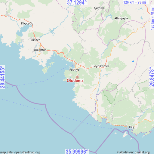
Ölüdeniz GPS coordinates[2]
36° 34' 0.264" North, 29° 8' 40.812" East
| Map corner | latitude | longitude |
|---|---|---|
| Upper-left | 37.1294°, | 28.44155° |
| Center: | 36.56674°, | 29.14467° |
| Lower-right: | 35.99996°, | 29.8478° |
| Map W x H: | 125.6×125.6 km | = 78×78mi |
| max Lat: | 42.02683° ⇑96.7% North |
| Ölüdeniz: | 36.56674° |
| min Lat: | ⇓3.3% South 35.9025° |
| min Long | Ölüdeniz | max Long |
| 25.90902° | 29.14467° | 44.60099° |
| W 17.6%⇐ | ⇒82.4% E |
Elevation
Elevation of Ölüdeniz is 353 m = 1158 ft, and this is 364.4 m = 1196 ft below average elevation for this country.
| Max E: |
2682 m = 8799 ft | 68.4% |
| Avg. | 717.4 m = 2354 ft | |
| Ölüdeniz | 353 m = 1158 ft | |
Min E: |
0 m = 0 ft | 31.6% |
See also: Turkey elevation on elevation.city.
Geographical zone
Ölüdeniz is located in North temperate zone (between Tropic of Cancer and the Arctic Circle). Distance of this Northern Tropic circle is 1459.9 km =907.1 mi to South.| Distance of | km | miles | from Ölüdeniz |
|---|---|---|---|
| North Pole | 5941.2 | 3691.7 | to North |
| Arctic Circle | 3335.3 | 2072.5 | to North |
| Tropic Cancer | 1459.9 | 907.1 | to South |
| Equator | 4065.8 | 2526.4 | to South |


Nearby cities:
15 places around Ölüdeniz: (largest is in red/bold)
• Akçay
53.9 km =33.5 mi,  85°
85°
• Dalaman
37.7 km =23.4 mi,  305°
305°
• Dalyan
53.6 km =33.3 mi,  303°
303°
• Eşen
17.5 km =10.9 mi,  135°
135°
• Fethiye
8.3 km =5.2 mi,  349°
349°
• Göcek
27.3 km =17 mi,  319°
319°
• Kalkan
41.3 km =25.7 mi, 144°
• Kargı
16.2 km =10.1 mi,  337°
337°
• Kemer
21.2 km =13.2 mi,  64°
64°
• Kızılyaka
57.5 km =35.7 mi,  36°
36°
• Ortaca
45.4 km =28.2 mi, 311°
• Sarigerme
42.6 km =26.5 mi,  292°
292°
• Seki
52.3 km =32.5 mi, 59°
• Yaniklar
17.8 km =11.1 mi,  331°
331°
• Yeşilüzümlü
20.2 km =12.6 mi,  23°
23°
Sources, notices
• [Note1] Compared only with cities in Turkey existing in our database
• [Src1] Map data: © OpenStreetMap contributors (CC-BY-SA)
• [Src2] Other city data from geonames.org with taken over terms of usage.
• [Src3] Geographical zone / Annual Mean Temperature by Robert A. Rohde @ Wikipedia
