Yaniklar geodata
Yaniklar (Muğla) is a populated place; located in Turkey in Europe/Istanbul (GMT+3) time zone. With population of 2,598 people, there are 893 cities with bigger population in this country. Compared to other cities in Turkey, 95.1% of cities are located further ↑North; 83.7% of cities are located further →East and 93.9% of cities have higher elevation than Yaniklar. Note1


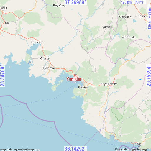
Yaniklar GPS coordinates[2]
36° 42' 29.772" North, 29° 3' 2.916" East
| Map corner | latitude | longitude |
|---|---|---|
| Upper-left | 37.26989°, | 28.34769° |
| Center: | 36.70827°, | 29.05081° |
| Lower-right: | 36.14252°, | 29.75394° |
| Map W x H: | 125.4×125.4 km | = 77.9×77.9mi |
| max Lat: | 42.02683° ⇑95.1% North |
| Yaniklar: | 36.70827° |
| min Lat: | ⇓4.9% South 35.9025° |
| min Long | Yaniklar | max Long |
| 25.90902° | 29.05081° | 44.60099° |
| W 16.3%⇐ | ⇒83.7% E |
Elevation
Elevation of Yaniklar is 21 m = 69 ft, and this is 696.4 m = 2285 ft below average elevation for this country.
| Max E: |
2682 m = 8799 ft | 93.9% |
| Avg. | 717.4 m = 2354 ft | |
| Yaniklar | 21 m = 69 ft | |
Min E: |
0 m = 0 ft | 6.1% |
See also: Turkey elevation on elevation.city.
Geographical zone
Yaniklar is located in North temperate zone (between Tropic of Cancer and the Arctic Circle). Distance of this Northern Tropic circle is 1475.7 km =917 mi to South.| Distance of | km | miles | from Yaniklar |
|---|---|---|---|
| North Pole | 5925.5 | 3681.9 | to North |
| Arctic Circle | 3319.6 | 2062.7 | to North |
| Tropic Cancer | 1475.7 | 917 | to South |
| Equator | 4081.6 | 2536.2 | to South |


Nearby cities:
15 places around Yaniklar: (largest is in red/bold)
• Altınyayla
54.5 km =33.9 mi,  53°
53°
• Dalaman
23 km =14.3 mi,  286°
286°
• Dalyan
38.8 km =24.1 mi, 291°
• Eşen
34.9 km =21.7 mi,  143°
143°
• Fethiye
10.2 km =6.3 mi, 137°
• Göcek
10.6 km =6.6 mi,  298°
298°
• Kargı
2.3 km =1.4 mi,  109°
109°
• Kemer
28.3 km =17.6 mi,  103°
103°
• Kızılyaka
52.3 km =32.5 mi, 54°
• Ortaca
29.4 km =18.3 mi, 299°
• Sarigerme
30.9 km =19.2 mi,  271°
271°
• Seki
54.6 km =33.9 mi,  78°
78°
• Yeşilüzümlü
16.5 km =10.3 mi, 80°
• Çameli
48.5 km =30.1 mi,  32°
32°
• Ölüdeniz
17.8 km =11.1 mi,  151°
151°
Sources, notices
• [Note1] Compared only with cities in Turkey existing in our database
• [Src1] Map data: © OpenStreetMap contributors (CC-BY-SA)
• [Src2] Other city data from geonames.org with taken over terms of usage.
• [Src3] Geographical zone / Annual Mean Temperature by Robert A. Rohde @ Wikipedia
