Fethiye geodata
Fethiye (Muğla) is a seat of a second-order administrative division; located in Turkey in Europe/Istanbul (GMT+3) time zone. With population of 60,437 people, there are 148 cities with bigger population in this country. Compared to other cities in Turkey, 96% of cities are located further ↑North; 82.6% of cities are located further →East and 98.3% of cities have higher elevation than Fethiye. Note1


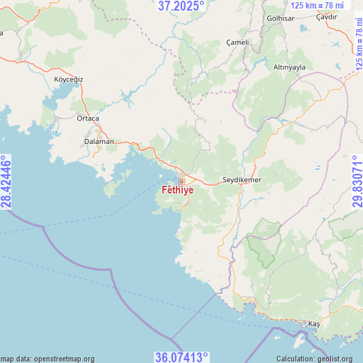
Fethiye GPS coordinates[2]
36° 38' 25.368" North, 29° 7' 39.288" East
| Map corner | latitude | longitude |
|---|---|---|
| Upper-left | 37.2025°, | 28.42446° |
| Center: | 36.64038°, | 29.12758° |
| Lower-right: | 36.07413°, | 29.83071° |
| Map W x H: | 125.5×125.5 km | = 78×78mi |
| max Lat: | 42.02683° ⇑96% North |
| Fethiye: | 36.64038° |
| min Lat: | ⇓4% South 35.9025° |
| min Long | Fethiye | max Long |
| 25.90902° | 29.12758° | 44.60099° |
| W 17.4%⇐ | ⇒82.6% E |
Elevation
Elevation of Fethiye is 9 m = 30 ft, and this is 708.4 m = 2324 ft below average elevation for this country.
| Max E: |
2682 m = 8799 ft | 98.3% |
| Avg. | 717.4 m = 2354 ft | |
| Fethiye | 9 m = 30 ft | |
Min E: |
0 m = 0 ft | 1.7% |
See also: Fethiye elevation on elevation.city.
Geographical zone
Fethiye is located in North temperate zone (between Tropic of Cancer and the Arctic Circle). Distance of this Northern Tropic circle is 1468.1 km =912.2 mi to South.| Distance of | km | miles | from Fethiye |
|---|---|---|---|
| North Pole | 5933 | 3686.6 | to North |
| Arctic Circle | 3327.1 | 2067.4 | to North |
| Tropic Cancer | 1468.1 | 912.2 | to South |
| Equator | 4074 | 2531.5 | to South |


Nearby cities:
15 places around Fethiye: (largest is in red/bold)
• Dalaman
32.1 km =19.9 mi,  295°
295°
• Dalyan
48.1 km =29.9 mi, 296°
• Eşen
24.8 km =15.4 mi,  146°
146°
• Göcek
20.5 km =12.7 mi,  307°
307°
• Kalkan
48.9 km =30.4 mi, 148°
• Kargı
8.2 km =5.1 mi,  325°
325°
• Kemer
20.7 km =12.9 mi,  87°
87°
• Kızılyaka
52.2 km =32.4 mi,  43°
43°
• Ortaca
39.2 km =24.4 mi, 304°
• Sarigerme
38.7 km =24 mi,  282°
282°
• Seki
50.1 km =31.1 mi,  68°
68°
• Yaniklar
10.2 km =6.3 mi,  317°
317°
• Yeşilüzümlü
14 km =8.7 mi, 42°
• Çameli
52.2 km =32.4 mi,  21°
21°
• Ölüdeniz
8.3 km =5.2 mi,  169°
169°
Sources, notices
• [Note1] Compared only with cities in Turkey existing in our database
• [Src1] Map data: © OpenStreetMap contributors (CC-BY-SA)
• [Src2] Other city data from geonames.org with taken over terms of usage.
• [Src3] Geographical zone / Annual Mean Temperature by Robert A. Rohde @ Wikipedia
