Dalaman geodata
Dalaman (Muğla) is a seat of a second-order administrative division; located in Turkey in Europe/Istanbul (GMT+3) time zone. With population of 19,292 people, there are 340 cities with bigger population in this country. Compared to other cities in Turkey, 93.9% of cities are located further ↑North; 85.5% of cities are located further →East and 95% of cities have higher elevation than Dalaman. Note1


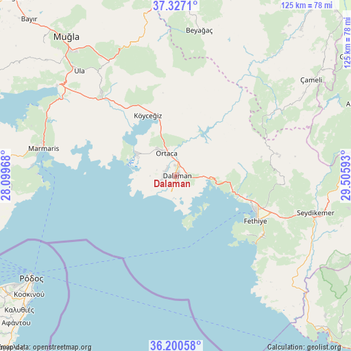
Dalaman GPS coordinates[2]
36° 45' 57.276" North, 28° 48' 10.08" East
| Map corner | latitude | longitude |
|---|---|---|
| Upper-left | 37.3271°, | 28.09968° |
| Center: | 36.76591°, | 28.8028° |
| Lower-right: | 36.20058°, | 29.50593° |
| Map W x H: | 125.3×125.3 km | = 77.9×77.9mi |
| max Lat: | 42.02683° ⇑93.9% North |
| Dalaman: | 36.76591° |
| min Lat: | ⇓6.1% South 35.9025° |
| min Long | Dalaman | max Long |
| 25.90902° | 28.8028° | 44.60099° |
| W 14.5%⇐ | ⇒85.5% E |
Elevation
Elevation of Dalaman is 16 m = 52 ft, and this is 701.4 m = 2301 ft below average elevation for this country.
| Max E: |
2682 m = 8799 ft | 95% |
| Avg. | 717.4 m = 2354 ft | |
| Dalaman | 16 m = 52 ft | |
Min E: |
0 m = 0 ft | 5% |
See also: Turkey elevation on elevation.city.
Geographical zone
Dalaman is located in North temperate zone (between Tropic of Cancer and the Arctic Circle). Distance of this Northern Tropic circle is 1482.1 km =920.9 mi to South.| Distance of | km | miles | from Dalaman |
|---|---|---|---|
| North Pole | 5919.1 | 3678 | to North |
| Arctic Circle | 3313.2 | 2058.7 | to North |
| Tropic Cancer | 1482.1 | 920.9 | to South |
| Equator | 4088 | 2540.2 | to South |


Nearby cities:
15 places around Dalaman: (largest is in red/bold)
• Beyağaç
52.8 km =32.8 mi,  9°
9°
• Dalyan
16 km =9.9 mi,  298°
298°
• Eşen
55 km =34.2 mi,  128°
128°
• Fethiye
32.1 km =19.9 mi,  115°
115°
• Göcek
12.8 km =8 mi,  96°
96°
• Kargı
25.3 km =15.7 mi,  106°
106°
• Kemer
51.3 km =31.9 mi, 104°
• Marmaris
48.1 km =29.9 mi,  281°
281°
• Ortaca
8.8 km =5.5 mi,  337°
337°
• Sarigerme
10.4 km =6.5 mi,  237°
237°
• Ula
51 km =31.7 mi,  317°
317°
• Yaniklar
23 km =14.3 mi, 106°
• Yeşilüzümlü
38.5 km =23.9 mi, 95°
• Çameli
59.2 km =36.8 mi,  54°
54°
• Ölüdeniz
37.7 km =23.4 mi, 125°
Sources, notices
• [Note1] Compared only with cities in Turkey existing in our database
• [Src1] Map data: © OpenStreetMap contributors (CC-BY-SA)
• [Src2] Other city data from geonames.org with taken over terms of usage.
• [Src3] Geographical zone / Annual Mean Temperature by Robert A. Rohde @ Wikipedia
