Sarigerme geodata
Sarigerme (Muğla) is a populated place; located in Turkey in Europe/Istanbul (GMT+3) time zone. With population of 16,000 people, there are 378 cities with bigger population in this country. Compared to other cities in Turkey, 94.9% of cities are located further ↑North; 85.8% of cities are located further →East and 92.6% of cities have higher elevation than Sarigerme. Note1


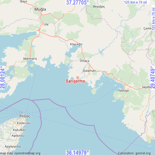
Sarigerme GPS coordinates[2]
36° 42' 55.764" North, 28° 42' 15.696" East
| Map corner | latitude | longitude |
|---|---|---|
| Upper-left | 37.27705°, | 28.00124° |
| Center: | 36.71549°, | 28.70436° |
| Lower-right: | 36.14979°, | 29.40749° |
| Map W x H: | 125.3×125.3 km | = 77.9×77.9mi |
| max Lat: | 42.02683° ⇑94.9% North |
| Sarigerme: | 36.71549° |
| min Lat: | ⇓5.1% South 35.9025° |
| min Long | Sarigerme | max Long |
| 25.90902° | 28.70436° | 44.60099° |
| W 14.2%⇐ | ⇒85.8% E |
Elevation
Elevation of Sarigerme is 26 m = 85 ft, and this is 691.4 m = 2268 ft below average elevation for this country.
| Max E: |
2682 m = 8799 ft | 92.6% |
| Avg. | 717.4 m = 2354 ft | |
| Sarigerme | 26 m = 85 ft | |
Min E: |
0 m = 0 ft | 7.4% |
See also: Turkey elevation on elevation.city.
Geographical zone
Sarigerme is located in North temperate zone (between Tropic of Cancer and the Arctic Circle). Distance of this Northern Tropic circle is 1476.5 km =917.5 mi to South.| Distance of | km | miles | from Sarigerme |
|---|---|---|---|
| North Pole | 5924.7 | 3681.4 | to North |
| Arctic Circle | 3318.8 | 2062.2 | to North |
| Tropic Cancer | 1476.5 | 917.5 | to South |
| Equator | 4082.4 | 2536.7 | to South |


Nearby cities:
15 places around Sarigerme: (largest is in red/bold)
• Bozburun
59 km =36.7 mi,  267°
267°
• Dalaman
10.4 km =6.5 mi,  57°
57°
• Dalyan
14.2 km =8.8 mi,  338°
338°
• Eşen
59.1 km =36.7 mi,  119°
119°
• Fethiye
38.7 km =24 mi,  102°
102°
• Göcek
21.9 km =13.6 mi,  78°
78°
• Kargı
33.1 km =20.6 mi,  92°
92°
• Kemer
58.9 km =36.6 mi, 97°
• Marmaris
41.3 km =25.7 mi,  292°
292°
• Menteşe
59.2 km =36.8 mi,  318°
318°
• Ortaca
14.8 km =9.2 mi,  21°
21°
• Ula
50.3 km =31.3 mi,  329°
329°
• Yaniklar
30.9 km =19.2 mi, 91°
• Yeşilüzümlü
47.2 km =29.3 mi, 87°
• Ölüdeniz
42.6 km =26.5 mi,  112°
112°
Sources, notices
• [Note1] Compared only with cities in Turkey existing in our database
• [Src1] Map data: © OpenStreetMap contributors (CC-BY-SA)
• [Src2] Other city data from geonames.org with taken over terms of usage.
• [Src3] Geographical zone / Annual Mean Temperature by Robert A. Rohde @ Wikipedia
