Altpınar geodata
Altpınar (Ankara) is a populated place; located in Turkey in Europe/Istanbul (GMT+3) time zone. With population of 12,925 people, there are 427 cities with bigger population in this country. Compared to other cities in Turkey, 57.4% of cities are located further ↓South; 63.2% of cities are located further →East and 72.3% of cities have lower elevation than Altpınar. Note1


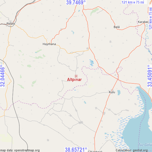
Altpınar GPS coordinates[2]
39° 12' 15.012" North, 32° 44' 52.008" East
| Map corner | latitude | longitude |
|---|---|---|
| Upper-left | 39.7469°, | 32.04466° |
| Center: | 39.20417°, | 32.74778° |
| Lower-right: | 38.65721°, | 33.45091° |
| Map W x H: | 121.2×121.2 km | = 75.3×75.3mi |
| max Lat: | 42.02683° ⇑42.6% North |
| Altpınar: | 39.20417° |
| min Lat: | ⇓57.4% South 35.9025° |
| min Long | Altpınar | max Long |
| 25.90902° | 32.74778° | 44.60099° |
| W 36.8%⇐ | ⇒63.2% E |
Elevation
Elevation of Altpınar is 1062 m = 3484 ft, and this is 344.6 m = 1131 ft above average elevation for this country.
| Max E: |
2682 m = 8799 ft | 27.7% |
| Altpınar | 1062 m 3484 ft | |
| Avg. | 717.4 m = 2354 ft | |
Min E: |
0 m = 0 ft | 72.3% |
See also: Turkey elevation on elevation.city.
Geographical zone
Altpınar is located in North temperate zone (between Tropic of Cancer and the Arctic Circle). Distance of this Northern Tropic circle is 1753.2 km =1089.4 mi to South.| Distance of | km | miles | from Altpınar |
|---|---|---|---|
| North Pole | 5648 | 3509.5 | to North |
| Arctic Circle | 3042.1 | 1890.3 | to North |
| Tropic Cancer | 1753.2 | 1089.4 | to South |
| Equator | 4359.1 | 2708.6 | to South |


Nearby cities:
15 places around Altpınar: (largest is in red/bold)
• Bala
50.6 km =31.4 mi,  39°
39°
• Cihanbeyli
62.3 km =38.7 mi,  165°
165°
• Gölbaşı
65.4 km =40.6 mi,  4°
4°
• Haymana
33.3 km =20.7 mi,  319°
319°
• Karakeçili
69.4 km =43.1 mi,  51°
51°
• Kulu
31.1 km =19.3 mi,  112°
112°
• Kuyulusebil
64 km =39.8 mi,  197°
197°
• Polatlı
66.6 km =41.4 mi,  308°
308°
• Sülüklü
50.2 km =31.2 mi,  224°
224°
• Temelli
67.2 km =41.8 mi,  329°
329°
• Yenice
9.8 km =6.1 mi, 323°
• Yeniceoba
37.4 km =23.2 mi, 174°
• Yenimehmetli
55.3 km =34.4 mi,  295°
295°
• Çelebi
72.8 km =45.2 mi,  66°
66°
• İkizce
44.1 km =27.4 mi,  350°
350°
Sources, notices
• [Note1] Compared only with cities in Turkey existing in our database
• [Src1] Map data: © OpenStreetMap contributors (CC-BY-SA)
• [Src2] Other city data from geonames.org with taken over terms of usage.
• [Src3] Geographical zone / Annual Mean Temperature by Robert A. Rohde @ Wikipedia
