Karakeçili geodata
Karakeçili (Kırıkkale) is a seat of a second-order administrative division; located in Turkey in Europe/Istanbul (GMT+3) time zone. With population of 8,468 people, there are 557 cities with bigger population in this country. Compared to other cities in Turkey, 62.8% of cities are located further ↓South; 61% of cities are located further →East and 57.6% of cities have lower elevation than Karakeçili. Note1


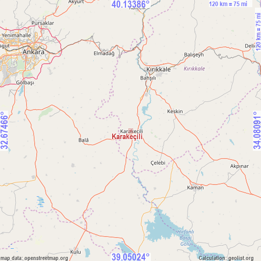
Karakeçili GPS coordinates[2]
39° 35' 39.012" North, 33° 22' 40.008" East
| Map corner | latitude | longitude |
|---|---|---|
| Upper-left | 40.13386°, | 32.67466° |
| Center: | 39.59417°, | 33.37778° |
| Lower-right: | 39.05024°, | 34.08091° |
| Map W x H: | 120.5×120.5 km | = 74.9×74.9mi |
| max Lat: | 42.02683° ⇑37.2% North |
| Karakeçili: | 39.59417° |
| min Lat: | ⇓62.8% South 35.9025° |
| min Long | Karakeçili | max Long |
| 25.90902° | 33.37778° | 44.60099° |
| W 39%⇐ | ⇒61% E |
Elevation
Elevation of Karakeçili is 837 m = 2746 ft, and this is 119.6 m = 392 ft above average elevation for this country.
| Max E: |
2682 m = 8799 ft | 42.4% |
| Karakeçili | 837 m 2746 ft | |
| Avg. | 717.4 m = 2354 ft | |
Min E: |
0 m = 0 ft | 57.6% |
See also: Turkey elevation on elevation.city.
Geographical zone
Karakeçili is located in North temperate zone (between Tropic of Cancer and the Arctic Circle). Distance of this Northern Tropic circle is 1796.5 km =1116.3 mi to South.| Distance of | km | miles | from Karakeçili |
|---|---|---|---|
| North Pole | 5604.6 | 3482.5 | to North |
| Arctic Circle | 2998.7 | 1863.3 | to North |
| Tropic Cancer | 1796.5 | 1116.3 | to South |
| Equator | 4402.5 | 2735.6 | to South |


Nearby cities:
15 places around Karakeçili: (largest is in red/bold)
• Akpınar
52.8 km =32.8 mi,  107°
107°
• Bahşılı
23.5 km =14.6 mi,  12°
12°
• Bala
22.2 km =13.8 mi,  258°
258°
• Balışeyh
46.2 km =28.7 mi,  39°
39°
• Elmadağ
38.4 km =23.9 mi,  340°
340°
• Gölbaşı
53.3 km =33.1 mi,  294°
294°
• Kalecik
56 km =34.8 mi,  2°
2°
• Kaman
39.7 km =24.7 mi,  131°
131°
• Keskin
22 km =13.7 mi,  66°
66°
• Kırıkkale
30 km =18.6 mi,  21°
21°
• Mamak
55.5 km =34.5 mi,  313°
313°
• Savcılı
48.3 km =30 mi,  147°
147°
• Yahşihan
29.2 km =18.1 mi, 12°
• Çankaya
56.9 km =35.4 mi, 309°
• Çelebi
19.1 km =11.9 mi,  139°
139°
Sources, notices
• [Note1] Compared only with cities in Turkey existing in our database
• [Src1] Map data: © OpenStreetMap contributors (CC-BY-SA)
• [Src2] Other city data from geonames.org with taken over terms of usage.
• [Src3] Geographical zone / Annual Mean Temperature by Robert A. Rohde @ Wikipedia
