Haymana geodata
Haymana (Ankara) is a seat of a second-order administrative division; located in Turkey in Europe/Istanbul (GMT+3) time zone. With population of 11,896 people, there are 451 cities with bigger population in this country. Compared to other cities in Turkey, 60.3% of cities are located further ↓South; 64.4% of cities are located further →East and 80.9% of cities have lower elevation than Haymana. Note1


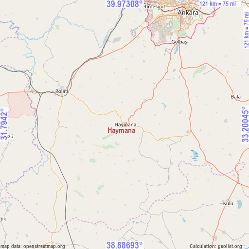
Haymana GPS coordinates[2]
39° 25' 55.632" North, 32° 29' 50.352" East
| Map corner | latitude | longitude |
|---|---|---|
| Upper-left | 39.97308°, | 31.7942° |
| Center: | 39.43212°, | 32.49732° |
| Lower-right: | 38.88693°, | 33.20045° |
| Map W x H: | 120.8×120.8 km | = 75.1×75.1mi |
| max Lat: | 42.02683° ⇑39.7% North |
| Haymana: | 39.43212° |
| min Lat: | ⇓60.3% South 35.9025° |
| min Long | Haymana | max Long |
| 25.90902° | 32.49732° | 44.60099° |
| W 35.6%⇐ | ⇒64.4% E |
Elevation
Elevation of Haymana is 1210 m = 3970 ft, and this is 492.6 m = 1616 ft above average elevation for this country.
| Max E: |
2682 m = 8799 ft | 19.1% |
| Haymana | 1210 m 3970 ft | |
| Avg. | 717.4 m = 2354 ft | |
Min E: |
0 m = 0 ft | 80.9% |
See also: Turkey elevation on elevation.city.
Geographical zone
Haymana is located in North temperate zone (between Tropic of Cancer and the Arctic Circle). Distance of this Northern Tropic circle is 1778.5 km =1105.1 mi to South.| Distance of | km | miles | from Haymana |
|---|---|---|---|
| North Pole | 5622.6 | 3493.7 | to North |
| Arctic Circle | 3016.7 | 1874.5 | to North |
| Tropic Cancer | 1778.5 | 1105.1 | to South |
| Equator | 4384.4 | 2724.3 | to South |


Nearby cities:
15 places around Haymana: (largest is in red/bold)
• Altpınar
33.3 km =20.7 mi,  139°
139°
• Ankara
62.2 km =38.6 mi,  29°
29°
• Bala
55.4 km =34.4 mi,  75°
75°
• Batikent
62.9 km =39.1 mi,  18°
18°
• Etimesgut
59.1 km =36.7 mi,  11°
11°
• Gölbaşı
48 km =29.8 mi, 33°
• Günyüzü
59.3 km =36.8 mi,  264°
264°
• Kulu
62.6 km =38.9 mi,  126°
126°
• Polatlı
34.5 km =21.4 mi,  297°
297°
• Sülüklü
62.7 km =39 mi,  192°
192°
• Temelli
35 km =21.7 mi,  339°
339°
• Yenice
23.5 km =14.6 mi, 137°
• Yenimehmetli
28.2 km =17.5 mi,  267°
267°
• Çankaya
62.4 km =38.8 mi, 30°
• İkizce
22.9 km =14.2 mi,  37°
37°
Sources, notices
• [Note1] Compared only with cities in Turkey existing in our database
• [Src1] Map data: © OpenStreetMap contributors (CC-BY-SA)
• [Src2] Other city data from geonames.org with taken over terms of usage.
• [Src3] Geographical zone / Annual Mean Temperature by Robert A. Rohde @ Wikipedia
