Polatlı geodata
Polatlı (Ankara) is a seat of a second-order administrative division; located in Turkey in Europe/Istanbul (GMT+3) time zone. With population of 93,262 people, there are 89 cities with bigger population in this country. Compared to other cities in Turkey, 62.5% of cities are located further ↓South; 66% of cities are located further →East and 58.5% of cities have lower elevation than Polatlı. Note1


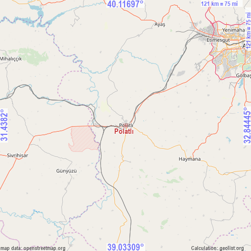
Polatlı GPS coordinates[2]
39° 34' 37.74" North, 32° 8' 28.752" East
| Map corner | latitude | longitude |
|---|---|---|
| Upper-left | 40.11697°, | 31.4382° |
| Center: | 39.57715°, | 32.14132° |
| Lower-right: | 39.03309°, | 32.84445° |
| Map W x H: | 120.5×120.5 km | = 74.9×74.9mi |
| max Lat: | 42.02683° ⇑37.5% North |
| Polatlı: | 39.57715° |
| min Lat: | ⇓62.5% South 35.9025° |
| min Long | Polatlı | max Long |
| 25.90902° | 32.14132° | 44.60099° |
| W 34%⇐ | ⇒66% E |
Elevation
Elevation of Polatlı is 855 m = 2805 ft, and this is 137.6 m = 451 ft above average elevation for this country.
| Max E: |
2682 m = 8799 ft | 41.5% |
| Polatlı | 855 m 2805 ft | |
| Avg. | 717.4 m = 2354 ft | |
Min E: |
0 m = 0 ft | 58.5% |
See also: Polatlı elevation on elevation.city.
Geographical zone
Polatlı is located in North temperate zone (between Tropic of Cancer and the Arctic Circle). Distance of this Northern Tropic circle is 1794.6 km =1115.1 mi to South.| Distance of | km | miles | from Polatlı |
|---|---|---|---|
| North Pole | 5606.5 | 3483.7 | to North |
| Arctic Circle | 3000.6 | 1864.5 | to North |
| Tropic Cancer | 1794.6 | 1115.1 | to South |
| Equator | 4400.6 | 2734.4 | to South |


Nearby cities:
15 places around Polatlı: (largest is in red/bold)
• Altpınar
66.6 km =41.4 mi,  128°
128°
• Ayaş
51.8 km =32.2 mi,  18°
18°
• Batikent
66.6 km =41.4 mi,  49°
49°
• Beypazarı
68.3 km =42.4 mi,  344°
344°
• Etimesgut
59.3 km =36.8 mi, 45°
• Gelegra
55.3 km =34.4 mi,  331°
331°
• Gölbaşı
61.9 km =38.5 mi,  67°
67°
• Günyüzü
35.7 km =22.2 mi,  232°
232°
• Haymana
34.5 km =21.4 mi,  117°
117°
• Mihalıçcık
63.9 km =39.7 mi,  300°
300°
• Sivrihisar
54 km =33.6 mi,  254°
254°
• Temelli
24.8 km =15.4 mi, 47°
• Yenice
57.2 km =35.5 mi, 125°
• Yenimehmetli
17.6 km =10.9 mi,  172°
172°
• İkizce
44.6 km =27.7 mi,  87°
87°
Sources, notices
• [Note1] Compared only with cities in Turkey existing in our database
• [Src1] Map data: © OpenStreetMap contributors (CC-BY-SA)
• [Src2] Other city data from geonames.org with taken over terms of usage.
• [Src3] Geographical zone / Annual Mean Temperature by Robert A. Rohde @ Wikipedia
