Yayladere geodata
Yayladere (Bingöl) is a populated place; located in Turkey in Europe/Istanbul (GMT+3) time zone. With population of 3,925 people, there are 784 cities with bigger population in this country. Compared to other cities in Turkey, 57.8% of cities are located further ↓South; 73.9% of cities are located further ←West and 92.7% of cities have lower elevation than Yayladere. Note1


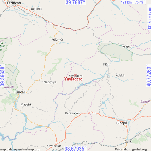
Yayladere GPS coordinates[2]
39° 13' 34.104" North, 40° 4' 10.2" East
| Map corner | latitude | longitude |
|---|---|---|
| Upper-left | 39.7687°, | 39.36638° |
| Center: | 39.22614°, | 40.0695° |
| Lower-right: | 38.67935°, | 40.77263° |
| Map W x H: | 121.1×121.1 km | = 75.2×75.2mi |
| max Lat: | 42.02683° ⇑42.2% North |
| Yayladere: | 39.22614° |
| min Lat: | ⇓57.8% South 35.9025° |
| min Long | Yayladere | max Long |
| 25.90902° | 40.0695° | 44.60099° |
| W 73.9%⇐ | ⇒26.1% E |
Elevation
Elevation of Yayladere is 1562 m = 5125 ft, and this is 844.6 m = 2771 ft above average elevation for this country.
| Max E: |
2682 m = 8799 ft | 7.3% |
| Yayladere | 1562 m 5125 ft | |
| Avg. | 717.4 m = 2354 ft | |
Min E: |
0 m = 0 ft | 92.7% |
See also: Turkey elevation on elevation.city.
Geographical zone
Yayladere is located in North temperate zone (between Tropic of Cancer and the Arctic Circle). Distance of this Northern Tropic circle is 1755.6 km =1090.9 mi to South.| Distance of | km | miles | from Yayladere |
|---|---|---|---|
| North Pole | 5645.5 | 3507.9 | to North |
| Arctic Circle | 3039.6 | 1888.7 | to North |
| Tropic Cancer | 1755.6 | 1090.9 | to South |
| Equator | 4361.5 | 2710.1 | to South |


Nearby cities:
15 places around Yayladere: (largest is in red/bold)
• Adaklı
35.6 km =22.1 mi,  89°
89°
• Balpayam
21.6 km =13.4 mi,  357°
357°
• Dallıbahçe
19.4 km =12.1 mi,  237°
237°
• Darıkent
37 km =23 mi,  217°
217°
• Dağyolu
37.4 km =23.2 mi,  338°
338°
• Dereova
17.5 km =10.9 mi,  278°
278°
• Karakoçan
30.7 km =19.1 mi,  186°
186°
• Kasaba
26.1 km =16.2 mi,  68°
68°
• Kocakoç
37.4 km =23.2 mi,  250°
250°
• Mezraa
27.6 km =17.1 mi,  310°
310°
• Nazimiye
21.4 km =13.3 mi,  256°
256°
• Pulumer
32.4 km =20.1 mi,  332°
332°
• Sancak
31.2 km =19.4 mi,  118°
118°
• Turluk
29 km =18 mi, 325°
• Çan
14.4 km =8.9 mi,  126°
126°
Sources, notices
• [Note1] Compared only with cities in Turkey existing in our database
• [Src1] Map data: © OpenStreetMap contributors (CC-BY-SA)
• [Src2] Other city data from geonames.org with taken over terms of usage.
• [Src3] Geographical zone / Annual Mean Temperature by Robert A. Rohde @ Wikipedia
